Andalusia, Alabama | |
|---|---|
| City of Andalusia | |
 First National Bank Building, Andalusia, 2014 | |
 Flag  Seal | |
| Motto: "A proud heritage. A progressive future." | |
 Location of Andalusia in Covington County, Alabama. | |
| Coordinates: 31°18′29″N 86°28′57″W / 31.30806°N 86.48250°W | |
| Country | United States |
| State | Alabama |
| County | Covington |
| Settled | 1841 |
| Incorporated | 1884 |
| Government | |
| • Mayor | Earl V. Johnson |
| Area | |
• Total | 19.81 sq mi (51.32 km2) |
| • Land | 19.66 sq mi (50.91 km2) |
| • Water | 0.16 sq mi (0.41 km2) |
| Elevation | 348 ft (106 m) |
| Population (2020) | |
• Total | 8,805 |
| • Density | 447.93/sq mi (172.95/km2) |
| Time zone | UTC-6 (CST) |
| • Summer (DST) | UTC-5 (CDT) |
| ZIP code | 36420 and 36421 |
| Area code | 334 |
| FIPS code | 01-01708 |
| GNIS feature ID | 0133361 |
| Website | Official website |
Andalusia is a city in and the county seat of Covington County, Alabama, United States. At the 2020 census, the population was 8,805.
History
[edit]Andalusia was first settled in 1841 after flooding of the Conecuh River and the surrounding lowlands forced citizens to move to higher ground. The county seat was moved from Montezuma to Andalusia in 1844. Andalusia likely got its name from Spanish explorers or settlers since the land where the town is located was part of Spanish Florida until Pinckney's Treaty in 1795. Andalusia shares its name with the autonomous community of Andalusia in southern Spain.[citation needed] The new town was originally called "New Site" but was known as Andalusia by the time a post office was established in 1846.[2]
Andalusia was incorporated as a town in 1884.[3]
In 1899, two railroad lines arrived in Andalusia, the Central of Georgia and the L & N Railroad, and the town began to grow.[4]
The Avant House is one of seven sites in Andalusia listed on the National Register of Historic Places.
Geography
[edit]Andalusia is located slightly northwest of the center of Covington County at 31°18′N 86°29′W / 31.300°N 86.483°W (31.309, -86.479).[5] According to the U.S. Census Bureau, the city has a total area of 19.8 square miles (51.3 km2), of which 19.7 square miles (50.9 km2) is land and 0.15 square miles (0.4 km2), or 0.79%, is water.[6]
Andalusia is served by the South Alabama Regional Airport, formerly known as the Andalusia-Opp Airport, located approximately 5 miles (8 km) east of the central business district.
Climate
[edit]The climate in this area is characterized by hot, humid summers and generally mild to cool winters. According to the Köppen Climate Classification system, Andalusia has a humid subtropical climate, abbreviated "Cfa" on climate maps.[7]
| Climate data for Andalusia, Alabama, 1991–2020 normals, extremes 1912–2018 | |||||||||||||
|---|---|---|---|---|---|---|---|---|---|---|---|---|---|
| Month | Jan | Feb | Mar | Apr | May | Jun | Jul | Aug | Sep | Oct | Nov | Dec | Year |
| Record high °F (°C) | 84 (29) |
87 (31) |
89 (32) |
97 (36) |
100 (38) |
105 (41) |
105 (41) |
105 (41) |
101 (38) |
99 (37) |
88 (31) |
84 (29) |
105 (41) |
| Mean maximum °F (°C) | 75.0 (23.9) |
77.3 (25.2) |
83.7 (28.7) |
87.5 (30.8) |
92.3 (33.5) |
96.3 (35.7) |
97.6 (36.4) |
97.0 (36.1) |
94.4 (34.7) |
89.2 (31.8) |
82.8 (28.2) |
77.3 (25.2) |
98.7 (37.1) |
| Mean daily maximum °F (°C) | 60.5 (15.8) |
64.6 (18.1) |
71.5 (21.9) |
77.7 (25.4) |
84.2 (29.0) |
89.0 (31.7) |
90.6 (32.6) |
90.2 (32.3) |
86.9 (30.5) |
79.1 (26.2) |
70.0 (21.1) |
62.8 (17.1) |
77.3 (25.1) |
| Daily mean °F (°C) | 47.9 (8.8) |
51.5 (10.8) |
57.8 (14.3) |
63.9 (17.7) |
71.6 (22.0) |
78.3 (25.7) |
80.4 (26.9) |
80.1 (26.7) |
76.0 (24.4) |
66.0 (18.9) |
55.7 (13.2) |
50.0 (10.0) |
64.9 (18.3) |
| Mean daily minimum °F (°C) | 35.2 (1.8) |
38.3 (3.5) |
44.0 (6.7) |
50.1 (10.1) |
59.1 (15.1) |
67.6 (19.8) |
70.2 (21.2) |
70.0 (21.1) |
65.1 (18.4) |
52.9 (11.6) |
41.5 (5.3) |
37.3 (2.9) |
52.6 (11.5) |
| Mean minimum °F (°C) | 17.9 (−7.8) |
21.3 (−5.9) |
26.2 (−3.2) |
32.7 (0.4) |
43.8 (6.6) |
55.4 (13.0) |
62.3 (16.8) |
62.1 (16.7) |
49.2 (9.6) |
34.0 (1.1) |
27.0 (−2.8) |
19.8 (−6.8) |
14.6 (−9.7) |
| Record low °F (°C) | 0 (−18) |
10 (−12) |
16 (−9) |
27 (−3) |
34 (1) |
44 (7) |
50 (10) |
54 (12) |
34 (1) |
28 (−2) |
16 (−9) |
2 (−17) |
0 (−18) |
| Average precipitation inches (mm) | 5.19 (132) |
4.62 (117) |
4.97 (126) |
4.86 (123) |
4.32 (110) |
5.65 (144) |
6.21 (158) |
6.34 (161) |
5.14 (131) |
3.40 (86) |
4.11 (104) |
5.45 (138) |
60.26 (1,530) |
| Average snowfall inches (cm) | 0.0 (0.0) |
0.0 (0.0) |
0.3 (0.76) |
0.0 (0.0) |
0.0 (0.0) |
0.0 (0.0) |
0.0 (0.0) |
0.0 (0.0) |
0.0 (0.0) |
0.0 (0.0) |
0.0 (0.0) |
0.0 (0.0) |
0.3 (0.76) |
| Average precipitation days (≥ 0.01 in) | 7.8 | 6.7 | 7.0 | 6.2 | 6.4 | 9.2 | 10.9 | 9.4 | 6.8 | 4.2 | 5.6 | 6.7 | 86.9 |
| Source: NOAA (mean maxima/minima 1981–2010)[8][9][10] | |||||||||||||
Andalusia
[edit]| Census | Pop. | Note | %± |
|---|---|---|---|
| 1880 | 596 | — | |
| 1890 | 270 | −54.7% | |
| 1900 | 551 | 104.1% | |
| 1910 | 2,480 | 350.1% | |
| 1920 | 4,023 | 62.2% | |
| 1930 | 5,154 | 28.1% | |
| 1940 | 6,886 | 33.6% | |
| 1950 | 9,162 | 33.1% | |
| 1960 | 10,263 | 12.0% | |
| 1970 | 10,092 | −1.7% | |
| 1980 | 10,415 | 3.2% | |
| 1990 | 9,269 | −11.0% | |
| 2000 | 8,794 | −5.1% | |
| 2010 | 9,015 | 2.5% | |
| 2020 | 8,805 | −2.3% | |
| U.S. Decennial Census[11] | |||
Andalusia first appeared on the 1880 U.S. Census as an unincorporated village.[12] It formally incorporated in 1884. See Andalusia Precinct/Division below.
2020 census
[edit]| Race | Num. | Perc. |
|---|---|---|
| White (non-Hispanic) | 5,829 | 66.2% |
| Black or African American (non-Hispanic) | 2,270 | 25.78% |
| Native American | 30 | 0.34% |
| Asian | 114 | 1.29% |
| Other/Mixed | 359 | 4.08% |
| Hispanic or Latino | 203 | 2.31% |
As of the 2020 United States census, there were 8,805 people, 3,490 households, and 2,147 families residing in the city.
2010 census
[edit]At the 2010 census there were 9,015 people in 3,694 households, including 2,359 families, in the city. The racial makeup of the city was 70.5% White, 25.9% Black or African American, 0.4% Native American, 1.0% Asian, 0.0% Pacific Islander, 0.4% from other races, and 1.7% from two or more races. 1.9% of the population were Hispanic or Latino of any race.[14] Of the 3,694 households 26.7% had children under the age of 18 living with them, 40.9% were married couples living together, 18.3% had a female householder with no husband present, and 36.1% were non-families. 31.3% of households were one person and 14.9% were one person aged 65 or older. The average household size was 2.35 and the average family size was 2.93.
The age distribution was 23.4% under the age of 18, 9.2% from 18 to 24, 23.6% from 25 to 44, 25.1% from 45 to 64, and 18.7% 65 or older. The median age was 39.7 years. For every 100 females, there were 86.6 males. For every 100 females age 18 and over, there were 91.2 males.
The median household income was $28,049 and the median family income was $37,059. Males had a median income of $27,228 versus $25,855 for females. The per capita income for the city was $19,544. About 20.2% of families and 22.8% of the population were below the poverty line, including 35.4% of those under age 18 and 14.5% of those age 65 or over.
2000 Census data
[edit]As of the census[15] of 2000, there were 8,794 people in 3,707 households, including 2,376 families, in the city.[16] The population density was 465.9 inhabitants per square mile (179.9/km2). There were 4,279 housing units at an average density of 226.7 per square mile (87.5/km2).[17] The racial makeup of the city was 73.93% White, 24.47% Black or African American, 0.36% Native American, 0.27% Asian, 0.02% Pacific Islander, 0.18% from other races, and 0.76% from two or more races. 0.78% of the population were Hispanic or Latino of any race.[16]
Of the 3,707 households 27.9% had children under the age of 18 living with them, 46.5% were married couples living together, 14.4% had a female householder with no husband present, and 35.9% were non-families. 33.3% of households were one person and 17.1% were one person aged 65 or older. The average household size was 2.29 and the average family size was 2.91.[16]
The age distribution was 23.2% under the age of 18, 8.4% from 18 to 24, 25.0% from 25 to 44, 22.6% from 45 to 64, and 20.8% 65 or older. The median age was 40 years. For every 100 females, there were 84.4 males. For every 100 females age 18 and over, there were 79.5 males.[16]
The median household income was $26,856 and the median family income was $37,091. Males had a median income of $29,406 versus $20,410 for females. The per capita income for the city was $17,292. About 15.7% of families and 20.6% of the population were below the poverty line, including 28.6% of those under age 18 and 18.9% of those age 65 or over.[16]
Andalusia Precinct/Division (1880-)
[edit]| Census | Pop. | Note | %± |
|---|---|---|---|
| 1880 | 729 | — | |
| 1890 | 1,371 | 88.1% | |
| 1900 | 2,051 | 49.6% | |
| 1910 | 4,388 | 113.9% | |
| 1920 | 6,057 | 38.0% | |
| 1930 | 7,680 | 26.8% | |
| 1940 | 9,647 | 25.6% | |
| 1950 | 10,882 | 12.8% | |
| 1960 | 10,263 | −5.7% | |
| 1970 | 10,092 | −1.7% | |
| 1980 | 18,168 | 80.0% | |
| 1990 | 18,275 | 0.6% | |
| 2000 | 18,646 | 2.0% | |
| 2010 | 18,495 | −0.8% | |
| U.S. Decennial Census[11] | |||
Andalusia Beat (Precinct) (Covington County 1st Beat) first appeared on the 1880 U.S. Census. In 1890, "beat" was changed to "precinct." In 1960, the precinct was changed to "census division" as part of a general reorganization of counties.[18] In 1980, three additional census divisions were consolidated into Andalusia, including Andalusia East, Andalusia West and Red Level.[19]
Andalusia East Census Division (1960-70)
[edit]| Census | Pop. | Note | %± |
|---|---|---|---|
| 1960 | 2,859 | — | |
| 1970 | 2,608 | −8.8% | |
| U.S. Decennial Census[11] | |||
Andalusia East Census Division was created in 1960 and contained the towns of Babbie, Heath, Libertyville and Sanford. In 1980, it was consolidated into Andalusia Census Division.
Andalusia West Census Division (1960-70)
[edit]| Census | Pop. | Note | %± |
|---|---|---|---|
| 1960 | 2,014 | — | |
| 1970 | 1,576 | −21.7% | |
| U.S. Decennial Census[11] | |||
Andalusia West Census Division was created in 1960. It did not contain any incorporated communities, and included the rural area west of the city of Andalusia to the Conecuh County line. In 1980, it was consolidated into Andalusia Census Division.
Media
[edit]- Cable TV Station
- WKNI 25 community interests
- Radio stations
- Newspaper
- Andalusia Star-News (daily)
City Council
[edit]| District | Name | Position |
|---|---|---|
| 1 | Mr. Joe Nix | Member |
| 2 | Mr. Kennith Mount | President |
| 3 | Mrs. Hazel Griffin | Member |
| 4 | Mr. Presley Boswell | Member |
| 5 | Mr. Terry Powell | Mayor Pro Tempore |
Education
[edit]Primary and secondary public education is provided by Andalusia City Schools, which consists of Andalusia Elementary School (Pre-K through 6th Grade), Andalusia Jr. High School (7th and 8th Grade), and Andalusia High School (9th through 12th Grade). Students can continue their studies at Lurleen B. Wallace Community College.
Transportation
[edit]Intercity bus service is provided by Greyhound Lines.[20] Local dial-a-ride transit service is provided by Covington Area Transit Service.[21]
Sites on the National Register of Historic Places
[edit]- The Bank of Andalusia
- Avant House
- Central of Georgia Depot, now converted into the Three Notch Museum
- Covington County Courthouse and Jail
- First National Bank Building
On July 4, 1975, a plaque monument was placed in front of the Covington County Courthouse by the Altrusa Club, as part of the commemoration of the United States Bicentennial. The plaque read "In memory of PHILIP NOLAN, Lieutenant in the Army of the United States. He loved his country as no other man has loved her; but no man deserved less at her hands."[22] Nolan is the protagonist of American writer Edward Everett Hale's fictional short story "The Man Without a Country", first published in The Atlantic in December 1863, during the Civil War.
Notable people
[edit]- Harold Albritton, U.S. district court judge
- Dempsey J. Barron, President of the Florida Senate from 1975 to 1976
- Charles Brooks, editorial cartoonist
- James U. Cross, retired U.S. Air Force brigadier general and chief Air Force One pilot under president Lyndon B. Johnson
- Cecil O. De Loach, Jr., California grape-grower and winemaker
- Quinton Dial, defensive tackle for the Alabama Crimson Tide
- Irwin Gunsalus, biochemist; assistant secretary general at the United Nations
- Seth Hammett, Speaker of the Alabama House of Representatives
- Robert Horry, basketball player, one of only two players to have won the National Basketball Association championship with three different teams
- Nico Johnson, one of two members of the University of Alabama's football team to start in their National Championship victories in 2009, 2011 and 2012
- Alexa Jones, Miss Alabama 2005 and Miss America 2006 (second runner-up)[23]
- T. D. Little, member of Alabama Senate and House of Representatives
- Lamar Morris, country music singer
- Mackey Sasser, former MLB catcher
- Frank J. Tipler, mathematical physicist and cosmologist; author of books and papers about a mechanism for the resurrection of the dead
Gallery
[edit]-
 Andalusia Public Library, 2014
 -
 115 Sixth Avenue, Andalusia
 -
 208 S. Cotton Street, Andalusia
 -
 Clark Theatre, Andalusia
 -
 8-14 Court Square, Andalusia
 -
 201 South Three Notch Street, Andalusia
 -
 First United Methodist, Andalusia
 -
 121 Central Street, Andalusia
 -
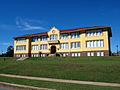
 Andalusia High School
 -
 Andalusia Ballet School (formerly Church Street School), Andalusia
 -
 Andalusia Junior High School
 -
 Andalusia City Hall
 -
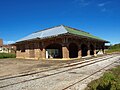 Old L&N Depot, Andalusia
 -
 Bank of Andalusia
 -
 Covington County Alabama Courthouse
 -
 Covington County Alabama Jail
 -
 Covington County Alabama Courthouse
 -
 Three Notch Museum


References
[edit]- ^ "2020 U.S. Gazetteer Files". United States Census Bureau. Retrieved October 29, 2021.
- ^ Hoskins Morton, Patricia (December 10, 2009). "Covington County". Encyclopedia of Alabama. Retrieved January 27, 2010.
- ^ Owen, Thomas McAdory; Marie Bankhead Owen (1921). History of Alabama and dictionary of Alabama biography, Volume 1. The S. J. Clarke Publishing Company. p. 716.
- ^ "Community - History of Andalusia". City of Andalusia official site. Retrieved December 10, 2014.
- ^ "US Gazetteer files: 2010, 2000, and 1990". United States Census Bureau. February 12, 2011. Retrieved April 23, 2011.
- ^ "Geographic Identifiers: 2010 Demographic Profile Data (G001): Andalusia city, Alabama". U.S. Census Bureau, American Factfinder. Archived from the original on February 12, 2020. Retrieved June 9, 2014.
- ^ "Andalusia, Alabama Köppen Climate Classification (Weatherbase)". Weatherbase.
- ^ "NowData - NOAA Online Weather Data". National Oceanic and Atmospheric Administration. Retrieved June 9, 2021.
- ^ "Station: Andalusia 3 W, AL". U.S. Climate Normals 2020: U.S. Monthly Climate Normals (1991-2020). National Oceanic and Atmospheric Administration. Retrieved June 9, 2021.
- ^ "Monthly Highest Max Temperature and Monthly Lowest Min Temperature for Andalusia 3 W, Al". Applied Climate Information System. Retrieved June 9, 2021.
- ^ a b c d "U.S. Decennial Census". Census.gov. Retrieved June 6, 2013.
- ^ 1880 AL Census
- ^ "Explore Census Data". data.census.gov. Retrieved December 17, 2021.
- ^ "U.S. Census website". United States Census Bureau. Retrieved July 20, 2015.
- ^ "U.S. Census website". United States Census Bureau. Retrieved January 31, 2008.
- ^ a b c d e "Fact Sheet- Andalusia city, Alabama". American Fast Facts. United States Census Bureau. Archived from the original on February 12, 2020. Retrieved January 27, 2010.
- ^ "Geographic Comparison Table- Alabama". American Fast Facts. United States Census Bureau. Archived from the original on February 12, 2020.
- ^ 1960 AL Census
- ^ 1980 AL Census
- ^ "Vinny's in Andalusia, Alabama | Greyhound". www.greyhound.com.
- ^ "CATS". Retrieved November 10, 2024.
- ^ "Philip Nolan Memorial – Andalusia, AL". Waymarking.com. February 19, 2013.
- ^ "Alexa Jones: Miss Alabama". Country Music Television. Archived from the original on July 14, 2014.
External links
[edit]![]() Media related to Andalusia, Alabama at Wikimedia Commons
Media related to Andalusia, Alabama at Wikimedia Commons
Municipalities and communities of Covington County, Alabama, United States | ||
|---|---|---|
| Cities |  | |
| Towns | ||
| Unincorporated communities | ||
| International | |
|---|---|
| National | |
| Geographic | |