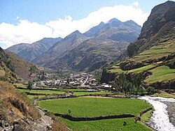
Aquia | |
|---|---|
 Aquia with the mountain Kikash in the background | |
 | |
| Country | |
| Region | Ancash |
| Province | Bolognesi |
| Founded | January 2, 1857 |
| Capital | Aquia |
| Government | |
| • Mayor | Ivo Dominovich Acuña Tapia |
| Area | |
• Total | 434.6 km2 (167.8 sq mi) |
| Elevation | 3,337 m (10,948 ft) |
| Population (2017) | |
• Total | 2,062 |
| • Density | 4.7/km2 (12/sq mi) |
| Time zone | UTC-5 (PET) |
| UBIGEO | 020504 |
Aquia District is one of fifteen districts of the province Bolognesi in Peru.[1]
Geography
[edit]The Cordillera Blanca and the Wallanka mountain range traverse the district. Some of the highest peaks of the district are listed below:[2]
- Challwa
- Ch'uspi
- Jupa Tawqaña
- Kallapu
- Kikash
- Kinwa Kuta
- Kuntur Wayi
- Minapata
- Mulli Mach'ay
- Munti Wayi
- Muntiyuq
- Pastu Ruri
- Puka Hirka
- Rahu Kutaq
- Shikra Shikra
- Tankan
- Tankanqucha
- Tawqan
- Tuku
- Wallanka
- Wamanripa
- Watiyaqucha
- Yanashallash
See also
[edit]References
[edit]- ^ (in Spanish) Instituto Nacional de Estadística e Informática. Banco de Información Distrital Archived April 23, 2008, at the Wayback Machine. Retrieved April 11, 2008.
- ^ escale.minedu.gob.pe - UGEL map of the Bolognesi Province (Ancash Region)
10°04′59″S 77°07′59″W / 10.08306°S 77.13306°W