This article needs additional citations for verification. (November 2014) |
Belfast Metropolitan Area | |
|---|---|
Metropolitan area | |
 Belfast Metropolitan Area Location in Northern Ireland | |
| Coordinates: 54°35′49″N 5°55′48″W / 54.597°N 5.930°W | |
| Sovereign State | United Kingdom |
| Constituent Country | Northern Ireland |
| District | |
| County | County Antrim / County Down |
| Government | |
| • UK Parliament | |
| Area | |
| • Total | 370 sq mi (960 km2) |
| Time zone | UTC+0 (GMT) |
| • Summer (DST) | UTC-1 (BST (WEST)) |
| Area code | 028 |
The Belfast metropolitan area, also known as Greater Belfast, is a grouping of council areas which include commuter towns and overspill from Belfast, Northern Ireland, with a population of 671,559[1] in 2011 and 704,406 in 2021.[2] The area combines the Belfast, Lisburn, Newtownabbey, North Down, Castlereagh and Carrickfergus districts from before the local government reorganization of 2014. This equates to 37.1% of Northern Ireland's population.
Overview
[edit]
The area was first officially classified as a metropolitan area in the late 1990s when the British government began to prepare for a cohesive plan that would include the Belfast Region. Six local government districts – Belfast, Castlereagh, Carrickfergus, Lisburn, Newtownabbey and North Down, were identified as the key areas within the metropolitan area. The continuous built-up area centred on Belfast, which is contained within these six districts, is defined as the Belfast Metropolitan Urban Area.[3] The Belfast metropolitan urban area had a population of 579,276 in 2001[4] and a population of 626,339 in 2021,[5] or 89% of the total population of the metropolitan area.
The area is made up of established towns, their overspill and the general conjoining of settlements as Belfast expands. Established towns include Carrickfergus, Bangor, Lisburn and Holywood. Many of these towns were established and important long before Belfast rose to prominence; Carrickfergus, for example, was the Norman capital of the northern part of Ireland until Edward Bruce's defeat in 1318.[6] Bangor had been an important centre of Christianity and learning from its foundation in 555 AD.[7][8] The recent reclassification of Lisburn as a city does not change its position within the metropolitan area.
Places in the conurbation
[edit]| Rank | Urban Area[4] | Population
(2001 Census)[4] |
Population
(2011 Census)[1] |
Population
(2021 Census)[5] |
|---|---|---|---|---|
| 1 | Belfast urban area | 276,605 | 280,138 | 293,300 |
| 2 | Lisburn urban area | 71,403 | 76,556 | 84,089 |
| 3 | Newtownabbey urban area | 62,022 | 65,646 | 67,599 |
| 4 | Bangor | 58,368 | 61,011 | 64,596 |
| 5 | Castlereagh urban area | 54,636 | 55,857 | 58,762 |
| 6 | Carrickfergus | 27,192 | 27,998 | 28,140 |
| 7 | Holywood urban area | 12,027 | 11,257 | 10,757 |
| 8 | Carryduff | 6,564 | 6,961 | 7,170 |
| 9 | Greenisland | 5,067 | 5,486 | 5,964 |
| 10 | Groomsport & Crawfordsburn | 1,401 | 1,795 | 1,718 |
| 11 | Helen's Bay | 1,356 | 1,385 | 1,547 |
| 12 | Milltown | 1,356 | 1,499 | 1,633 |
| 13 | Seahill | 1,179 | 1,014 | 1,055 |
| Total | Belfast metropolitan urban area | 579,276 | 596,603 | 626,332 |
2021 Census
[edit]The demographics of the Belfast Metropolitan Urban Area from the 2021 census are as follows:
- 19.3% were 15 and under, 22.4% were 60 and over
- 48.4% were male, 51.6% were female
- 37.2% were from a Catholic background, 46.8% were from a Protestant background.[5]
2001 Census
[edit]At the 2001 census, the demographic characteristics of the people living in Belfast metropolitan urban area (BMUA) were as follows:[9]
- 22.0% were aged under 16 years and 19.2% were aged 60 and over
- 47.4% of the population were male and 52.6% were female
- 34.4% were from a Catholic background, 60.9% were from a Protestant background.
- 4.3% of people aged 16–74 were unemployed
Population maps
[edit]The following maps show religious and national identity distributions from the 2021 census.

![Belfast Metropolitan Area 2021 Religious Background[10]](/wiki/File:Belfast_Metropolitan_Area.png)
![Predominant National Identity from 2021 Census[11]](/wiki/File:Belfast_Metropolitan_Area_National_Identity.png)
In the 2011 UK Census, the distributions of population, religion, national identity and proportion of immigrants within the Belfast metropolitan area, were as follows.
-
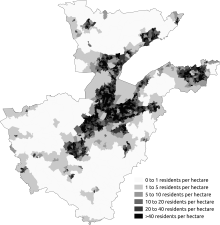 Population density
 -
 Percentage who were Catholic or brought up Catholic
 -
 Most commonly stated national identity
 -
 Percentage born outside the UK and the Republic of Ireland


References
[edit]- ^ a b "2011 Population by Settlement". NISRA. Retrieved 21 October 2024.
- ^ "Census 2021 Belfast Metropolitan Area population". Retrieved 22 October 2024.
- ^ "Map of Belfast Metropolitan Urban Area". Archived from the original on 4 June 2011. Retrieved 24 July 2007.
- ^ a b c "Statistical Classification Band A – Belfast Metropolitan Urban Area" (PDF). Nisra.gov.uk. Archived from the original (PDF) on 1 April 2014. Retrieved 21 November 2014.
- ^ a b c "2021 Population by Settlement". NISRA. Retrieved 20 October 2024.
- ^ Gwynn, Stephen Lucius (1903). Highways and byways in Donegal and Antrim. Macmillan and Co. limited. p. 291. Retrieved 8 April 2018.
capital.
- ^ Gauldie, Robin (2008). GLOBETROTTER Travel Guide IRELAND. New Holland Publishers. p. 118. ISBN 9781845378707. Retrieved 8 April 2018.
- ^ Hamlin, Ann; Kerr, Thomas R. (2008). The archaeology of early Christianity in the North of Ireland. Archaeopress. p. 285. ISBN 9781407302850. Retrieved 8 April 2018.
- ^ "Area Profile of Belfast Metropolitan Urban Area (BMUA)". Archived from the original on 19 February 2012. Retrieved 23 November 2012.
- ^ "Religious Background 2021". Northern Ireland Statistics and Research Agency. Retrieved 19 September 2024.
- ^ "National Identity 2021". Northern Ireland Statistics and Research Agency. Retrieved 19 September 2024.
.jpg)
.jpg)
See also
[edit]- Districts of Belfast
- Greater Dublin
- Derry Urban Area
- Greater Cork
- List of conurbations in the United Kingdom
- Dublin-Belfast corridor
| International | |
|---|---|
| Other | |