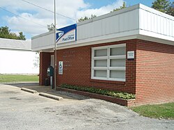
Bethpage, Tennessee | |
|---|---|
 Post office in Bethpage | |
| Coordinates: 36°28′54″N 86°18′43″W / 36.48167°N 86.31194°W | |
| Country | United States |
| State | Tennessee |
| County | Sumner |
| Area | |
• Total | 1.33 sq mi (3.44 km2) |
| • Land | 1.33 sq mi (3.44 km2) |
| • Water | 0.00 sq mi (0.00 km2) |
| Elevation | 545 ft (166 m) |
| Population | |
• Total | 313 |
| • Density | 235.69/sq mi (90.98/km2) |
| Time zone | UTC-6 (Central (CST)) |
| • Summer (DST) | UTC-5 (CDT) |
| Area code | 615 |
| GNIS feature ID | 1277178[3] |
Bethpage is an unincorporated community and census-designated place (CDP) in Sumner County, Tennessee, United States. It is located along U.S. Route 31E, northeast of neighboring Gallatin. As of the 2020 census, its population was 313, up from 288 at the 2010 census.[4] The area has its own Post Office. The United States Postal Service ZIP code for the Bethpage area is 37022.[5]
Demographics
[edit]| Census | Pop. | Note | %± |
|---|---|---|---|
| 2010 | 288 | — | |
| 2020 | 313 | 8.7% | |
| U.S. Decennial Census[6] | |||
Climate
[edit]| Climate data for Bethpage, Tennessee | |||||||||||||
|---|---|---|---|---|---|---|---|---|---|---|---|---|---|
| Month | Jan | Feb | Mar | Apr | May | Jun | Jul | Aug | Sep | Oct | Nov | Dec | Year |
| Mean daily maximum °F (°C) | 46 (8) |
49 (9) |
59 (15) |
69 (21) |
77 (25) |
86 (30) |
88 (31) |
88 (31) |
83 (28) |
71 (22) |
60 (16) |
48 (9) |
25 (−4) |
| Mean daily minimum °F (°C) | 27 (−3) |
35 (2) |
44 (7) |
53 (12) |
63 (17) |
66 (19) |
65 (18) |
58 (14) |
44 (7) |
35 (2) |
27 (−3) |
45 (7) |
36 (2) |
| Average precipitation inches (mm) | 4.4 (110) |
4.3 (110) |
5.2 (130) |
4.5 (110) |
5.4 (140) |
4 (100) |
4.4 (110) |
3.4 (86) |
3.6 (91) |
3.2 (81) |
4.3 (110) |
5 (130) |
51.8 (1,320) |
| Source: Weatherbase [7] | |||||||||||||
References
[edit]- ^ "ArcGIS REST Services Directory". United States Census Bureau. Retrieved October 15, 2022.
- ^ "Census Population API". United States Census Bureau. Retrieved October 15, 2022.
- ^ "Bethpage". Geographic Names Information System. United States Geological Survey, United States Department of the Interior.
- ^ "U.S. Census website". United States Census Bureau. Retrieved May 14, 2011.
- ^ United States Postal Service (2012). "USPS - Look Up a ZIP Code". Retrieved February 15, 2012.
- ^ "Census of Population and Housing". Census.gov. Retrieved June 4, 2016.
- ^ "Weatherbase.com". Weatherbase. 2013. Retrieved on August 11, 2013.

