Buhl | |
|---|---|
 The town hall in Buhl | |
| Coordinates: 47°55′43″N 7°11′14″E / 47.9286°N 7.1872°E | |
| Country | France |
| Region | Grand Est |
| Department | Haut-Rhin |
| Arrondissement | Thann-Guebwiller |
| Canton | Guebwiller |
| Intercommunality | Région de Guebwiller |
| Government | |
| • Mayor (2020–2026) | Yves Coquelle[1] |
Area 1 | 8.8 km2 (3.4 sq mi) |
| Population (2021)[2] | 3,199 |
| • Density | 360/km2 (940/sq mi) |
| Time zone | UTC+01:00 (CET) |
| • Summer (DST) | UTC+02:00 (CEST) |
| INSEE/Postal code | 68058 /68530 |
| Elevation | 313–842 m (1,027–2,762 ft) (avg. 340 m or 1,120 ft) |
| 1 French Land Register data, which excludes lakes, ponds, glaciers > 1 km2 (0.386 sq mi or 247 acres) and river estuaries. | |
Buhl (French pronunciation: [byl] ⓘ; German: Bühl) is a commune in the Haut-Rhin department in Grand Est in north-eastern France.
It inhabitants are called Buhlois (male) or Buhloises (female).
Geography
[edit]Buhl is situated in the valley of the Lauch, at the foot of the Vosges Mountains and the Grand Ballon (1424 m) and surrounded by forests whose hills reach altitudes ranging from 395 to 860 metres. The village is crossed by the Lauch, a gentle stream with clear, limpid water, in the heart of the Florival valley, 3 km from Guebwiller.
Buhl owes its name to its picturesque site on the Bühele hill, from which the village and church dominate a large part of the valley. The commune covers an area of 880 hectares and extends into two confluent valleys.
The commune is crossed by three water courses, the Lauch, the Murbach and the Krebsbach. Buhl looks over several forested hills which border the village:
- le Demberg (altitude 628 m)
- le Schimerg (582 m) whose steep sides are covered with vines
- le Geisskopf (735 m)
- l'Ebeneck (859 m)
- le Hochkopf (545 m) above the Château du Hugstein
Population
[edit]| Year | Pop. | ±% p.a. |
|---|---|---|
| 1968 | 2,945 | — |
| 1975 | 3,048 | +0.49% |
| 1982 | 2,674 | −1.85% |
| 1990 | 2,755 | +0.37% |
| 1999 | 3,079 | +1.24% |
| 2007 | 3,238 | +0.63% |
| 2012 | 3,310 | +0.44% |
| 2017 | 3,310 | +0.00% |
| Source: INSEE[3] | ||
History
[edit]This section is empty. You can help by adding to it. (July 2010) |
Sites and monuments
[edit]Église Saint-Jean-Baptiste (Church of St John the Baptist)
[edit]
The presence of a vicar in Buhl is recorded since 1243.
Of the original 13th-century church, all that remains is the tower, whose two upper levels were remodelled in the 18th century (the date 1748 is visible). The nave and choir were also probably remodelled in the 18th century.
Following a large growth in population in the 19th century, a new church was built to replace the old shrine. With a population of 2000, the municipality had decided that the old church was too small. It was replaced by a vast Neo-Romanesque edifice. Between 1868 and 1870, the architect Langestein built a new nave perpendicular to the old one which served as a choir. The Franco-Prussian War in 1870 interrupted construction, so it was not until 1877 that the remainder of the old church was demolished and a new choir was built by the architect Hartmann.
The top of the original tower was demolished in 1899 amid fears that it could fall. It was replaced with an octagonal bell tower by the architect Kreyer.[4]

Retable de la Crucifixion
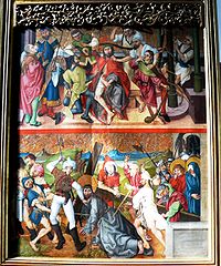
[edit]The church houses a 15th-century altarpiece consecrated to the Passion of Christ (open shutters) and to the Virgin Mary (closed shutters): the Buhl Altarpiece.
This masterpiece was taken to Colmar during the French Revolution when the convents were emptied of their furniture. After the Revolution, two inhabitants of Buhl brought the altarpiece back to the village hidden in a load of fodder.
The altarpiece probably originated in a Dominican convent, very probably that of the Catherinettes of Colmar. The style of the altarpiece suggests it is from the school of the Colmar artist Martin Schongauer (1448–1491).
From top to bottom, the picture shows the crown and thorns and the carrying of the cross.
Château du Hugstein
[edit]The Château du Hugstein is a ruined 13th-century castle.

Other sites
[edit]- Chapelle des Maquisards
- Chapelle Notre-Dame
- Calvaire du Rimlishof
- Chapelle du cimetière
- Chapelle Sainte Catherine
- Menhirs de l'Appenthal
Personalities linked to the commune
[edit]- Alexandre Bida: 19th-century painter, died in Buhl.
- Jean-Marie Haessle (1939-2024) painter, born and raised in Buhl
- Maurice Koechlin: structural engineer, designer of Eiffel Tower, born in Buhl
See also
[edit]References
[edit]- ^ "Répertoire national des élus: les maires". data.gouv.fr, Plateforme ouverte des données publiques françaises (in French). 2 December 2020.
- ^ "Populations légales 2021" (in French). The National Institute of Statistics and Economic Studies. 28 December 2023.
- ^ Population en historique depuis 1968, INSEE
- ^ Base Mérimée: Eglise Paroissiale Saint-Jean-Baptiste, Ministère français de la Culture. (in French)


