Clyde River
ᑲᖏᖅᑐᒑᐱᒃ Kangiqtugaapik | |
|---|---|
 Clyde River 1997 | |
| Coordinates: 70°28′05″N 068°35′40″W / 70.46806°N 68.59444°W[1] | |
| Country | Canada |
| Territory | Nunavut |
| Region | Qikiqtaaluk |
| Electoral district | Uqqummiut |
| Government | |
| • Mayor | Alan Cormack |
| • MLA | Mary Killiktee |
| Area (2021)[5] | |
| • Land | 103.38 km2 (39.92 sq mi) |
| Elevation | 27 m (89 ft) |
| Population (2021)[5] | |
• Total | 1,181 |
| • Density | 11.4/km2 (30/sq mi) |
| Time zone | UTC−05:00 (EST) |
| • Summer (DST) | UTC−04:00 (EDT) |
| Canadian Postal code | |
| Area code | 867 |
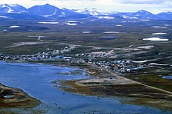
Clyde River (Syllabics: ᑲᖏᖅᑐᒑᐱᒃ,[7] Inuktitut: Kangiqtugaapik "nice little inlet"[8]) is an Inuit hamlet located on the shore of Baffin Island's Patricia Bay, off Kangiqtugaapik,[9] an arm of Davis Strait in the Qikiqtaaluk Region of Nunavut, Canada. It lies in the Baffin Mountains which in turn form part of the Arctic Cordillera mountain range. The community is served by air and by annual supply sealift.
The community is served by Quluaq School, the Northern Stores, an arena, a community hall, an Anglican church (the Church of the Redeemer[10]), a health centre, hotel and Clyde River Airport with regular flights to Iqaluit and Pond Inlet.
Geography
[edit]It is located on a flood plain, surrounded by spectacular fjords that stretch all the way into the Barnes Ice Cap. The mountains, icebergs and glaciers in the Clyde River area attract rock and ice climbers from around the world.
There is also a multitude of animals to be seen, including barren-ground caribou, narwhals, polar bears and other sea mammals. The proposed "Igaliqtuuq National Wildlife Area", which would be a protected bowhead whale sanctuary, is located in Isabella Bay.
Clyde River is home to Piqqusilirivvik, Nunavut's Inuit Cultural Learning Centre. Piqqusilirivvik opened its doors May 2011.
| Year | Pop. | ±% |
|---|---|---|
| 1976 | 352 | — |
| 1981 | 443 | +25.9% |
| 1986 | 471 | +6.3% |
| 1991 | 565 | +20.0% |
| 1996 | 708 | +25.3% |
| 2001 | 785 | +10.9% |
| 2006 | 820 | +4.5% |
| 2011 | 934 | +13.9% |
| 2016 | 1,053 | +12.7% |
| 2021 | 1,181 | +12.2% |
| Source: Statistics Canada [5][11][12][13][14][15][16][17][18] | ||
Demographics
[edit]In the 2021 Canadian census conducted by Statistics Canada, Clyde River had a population of 1,181 living in 258 of its 278 total private dwellings, a change of 12.2 per cent from its 2016 population of 1,053. With a land area of 103.38 km2 (39.92 sq mi), it had a population density of 11.4/km2 (29.6/sq mi) in 2021.[5]
Supreme Court case
[edit]On June 26, 2014, the National Energy Board (NEB) approved the 5-year plan to conduct seismic blasting off the coast of Baffin Island, jointly submitted by TGS-NOPEC Geophysical Company ASA (TGS), Petroleum Geo-Services (PGS) and Multi Klient Invest AS (MKI).[19] The approval sparked strong criticism from Inuit including the communities of Clyde River and Pond Inlet, the Arctic Fishery Alliance, the Baffin Fisheries Coalition and the Qikiqtani Inuit Association.[20] Okalik Eegeesiak, then-president of the Qikiqtani Inuit Association said "They still don't get the fact that Inuit have concerns and we want to be part of the process,"[21] while Inuit photographer and Clyde River resident Niore Iqalukjuak was quoted saying "We depend on these waters for food and the very existence of Inuit life depend on them...We fear that what the Conservative government is doing is a cultural genocide and will end the Inuit way of life as we know it"[22] and Clyde River Mayor, Jerry Natanine commented "Nobody cares for our concerns...And our Minister [of the Environment] in Ottawa, Leona Aglukkaq, not speaking up against this for Inuit is very wrong."[23]

Mayor Natanine approached the environmental organization Greenpeace Canada in hopes that they could work together to prevent seismic blasting operations from taking place.[24] This led to the development of a collaboration many dubbed "surprising" due to the history of taking opposing sides on the anti-sealing campaign of the 1970s and 80s.[25]
On July 23, 2014, the community of Clyde River staged a protest against the NEB's approval,[26] and on July 28 the Hamlet of Clyde River, the Nammautaq Hunters and Trappers Organization of Clyde River, and Clyde River Mayor Jerry Natanine filed a request for a judicial review at Federal Court of Appeal. The legal case argues that the NEB's decision goes against the government of Canada's duty to consult with Indigenous peoples under the United Nations Declaration on the Rights of Indigenous Peoples. Speaking of the importance of the case, constitutional lawyer Nader Hasan, who is representing Clyde River, argued: "The federal government has a solemn constitutional obligation to meaningfully consult and accommodate the people of Nunavut on any issues affecting their Aboriginal or treaty rights. That did not happen, and the NEB was again a rubber stamp for the energy industry."[27]
The Court of Appeal denied the request in August 2015. But the groups requested leave to appeal before the Supreme Court of Canada in October 2015, arguing that the Court of Appeal's decision was mistaken, and that the case is of national importance, thus needing further debate.[28] In November of the same year Greenpeace launched an international petition that has gathered over 129,000 signatures (as of July 2016)[29] in support of this legal challenge.
On March 10, 2016, the Supreme Court of Canada granted Clyde River leave to appeal their case at the country's highest court,[30] giving credence to the community's claim that their case is significant, thus needing further review by the courts. The hearing of the case was scheduled for November 20, 2016.
In July 2017, the Supreme Court ruled in Clyde River's favour, ruling that oil and gas exploration cannot go ahead.[31]
Broadband communications
[edit]The community has been served by the Qiniq network since 2005. Qiniq is a fixed wireless service to homes and businesses, connecting to the outside world via a satellite backbone. The Qiniq network is designed and operated by SSI Micro. In 2017, the network was upgraded to 4G LTE technology, and 2G-GSM for mobile voice.
Climate
[edit]Clyde River has a tundra climate (ET) with short but cool summers and long cold winters.
| Climate data for Clyde River (Clyde River Airport) WMO ID: 71090; coordinates 70°29′10″N 68°31′00″W / 70.48611°N 68.51667°W; elevation: 26.5 m (87 ft); 1991–2020 normals, extremes 1933–present | |||||||||||||
|---|---|---|---|---|---|---|---|---|---|---|---|---|---|
| Month | Jan | Feb | Mar | Apr | May | Jun | Jul | Aug | Sep | Oct | Nov | Dec | Year |
| Record high humidex | 2.2 | 1.7 | 0.1 | 7.2 | 8.5 | 16.1 | 23.6 | 20.7 | 14.4 | 8.1 | 1.7 | 1.7 | 23.6 |
| Record high °C (°F) | 3.3 (37.9) |
3.3 (37.9) |
0.2 (32.4) |
11.7 (53.1) |
8.9 (48.0) |
17.8 (64.0) |
22.2 (72.0) |
20.6 (69.1) |
14.6 (58.3) |
11.4 (52.5) |
6.7 (44.1) |
2.8 (37.0) |
22.2 (72.0) |
| Mean daily maximum °C (°F) | −24.2 (−11.6) |
−25.1 (−13.2) |
−22.0 (−7.6) |
−13.4 (7.9) |
−3.7 (25.3) |
3.8 (38.8) |
9.2 (48.6) |
8.2 (46.8) |
3.3 (37.9) |
−2.9 (26.8) |
−12.3 (9.9) |
−19.0 (−2.2) |
−8.2 (17.2) |
| Daily mean °C (°F) | −28.0 (−18.4) |
−29.0 (−20.2) |
−26.6 (−15.9) |
−18.2 (−0.8) |
−7.6 (18.3) |
1.0 (33.8) |
5.3 (41.5) |
5.0 (41.0) |
0.7 (33.3) |
−6.3 (20.7) |
−16.0 (3.2) |
−23.0 (−9.4) |
−11.9 (10.6) |
| Mean daily minimum °C (°F) | −31.8 (−25.2) |
−32.8 (−27.0) |
−31.2 (−24.2) |
−23.0 (−9.4) |
−11.3 (11.7) |
−1.6 (29.1) |
1.6 (34.9) |
1.9 (35.4) |
−1.6 (29.1) |
−9.3 (15.3) |
−19.6 (−3.3) |
−26.8 (−16.2) |
−15.5 (4.1) |
| Record low °C (°F) | −50.2 (−58.4) |
−50.1 (−58.2) |
−47.8 (−54.0) |
−41.1 (−42.0) |
−31.1 (−24.0) |
−17.2 (1.0) |
−6.8 (19.8) |
−5.6 (21.9) |
−16.1 (3.0) |
−28.7 (−19.7) |
−39.5 (−39.1) |
−45.0 (−49.0) |
−50.2 (−58.4) |
| Record low wind chill | −59.5 | −62.4 | −58.1 | −48.9 | −34.4 | −20.0 | −10.5 | −9.5 | −21.2 | −36.4 | −46.7 | −55.3 | −62.4 |
| Average precipitation mm (inches) | 10.4 (0.41) |
8.1 (0.32) |
11.9 (0.47) |
10.9 (0.43) |
15.0 (0.59) |
20.3 (0.80) |
25.0 (0.98) |
28.7 (1.13) |
37.9 (1.49) |
30.0 (1.18) |
18.4 (0.72) |
15.4 (0.61) |
231.9 (9.13) |
| Average rainfall mm (inches) | 0.0 (0.0) |
0.0 (0.0) |
0.0 (0.0) |
0.0 (0.0) |
0.5 (0.02) |
5.6 (0.22) |
14.5 (0.57) |
32.2 (1.27) |
10.2 (0.40) |
0.3 (0.01) |
0.0 (0.0) |
0.0 (0.0) |
63.3 (2.49) |
| Average snowfall cm (inches) | 10.6 (4.2) |
8.7 (3.4) |
8.4 (3.3) |
12.7 (5.0) |
16.5 (6.5) |
12.5 (4.9) |
6.6 (2.6) |
5.2 (2.0) |
27.7 (10.9) |
40.4 (15.9) |
28.2 (11.1) |
17.2 (6.8) |
194.7 (76.7) |
| Average precipitation days (≥ 0.2 mm) | 8.0 | 7.1 | 7.5 | 8.8 | 10.3 | 8.3 | 9.6 | 10.8 | 15.0 | 16.0 | 11.1 | 9.9 | 122.3 |
| Average rainy days (≥ 0.2 mm) | 0.0 | 0.0 | 0.0 | 0.0 | 0.3 | 1.6 | 6.6 | 9.1 | 3.8 | 0.3 | 0.1 | 0.0 | 21.8 |
| Average snowy days (≥ 0.2 cm) | 7.3 | 6.6 | 6.8 | 8.7 | 10.5 | 5.6 | 2.4 | 3.3 | 12.0 | 17.0 | 11.8 | 8.4 | 100.3 |
| Average relative humidity (%) (at 1500 LST) | 68.3 | 66.7 | 67.6 | 74.4 | 83.0 | 84.5 | 79.3 | 80.4 | 81.0 | 82.8 | 78.5 | 71.7 | 76.5 |
| Mean monthly sunshine hours | 0.0 | 56.1 | 175.6 | 253.3 | 264.1 | 273.4 | 279.0 | 161.6 | 83.9 | 45.5 | 0.0 | 0.0 | 1,592.5 |
| Percent possible sunshine | 0.0 | 28.6 | 48.8 | 51.8 | 37.9 | 38.0 | 37.6 | 28.0 | 20.7 | 16.4 | 0.0 | 0.0 | 34.2 |
| Source: Environment and Climate Change Canada[32] (rain/rain days, snow/snow days, sun 1981–2010)[33] | |||||||||||||
Gallery
[edit]-
Cultural centre
-
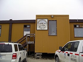
Hamlet offices
-
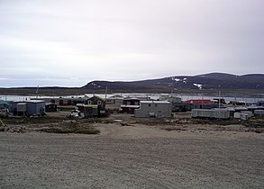
Another shot of Clyde River
-
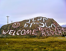
Rock with welcome sign on it
See also
[edit]References
[edit]- ^ "Clyde River". Geographical Names Data Base. Natural Resources Canada.
- ^ "Municipal Election Results 2019-2020" (PDF). Elections Nunavut. Retrieved December 26, 2022.
- ^ "2021 General Election" (PDF). Elections Nunavut. Retrieved December 26, 2022.
- ^ "Clyde River still searching for diesel after declaring state of emergency". Nunatsiaq News. February 14, 2022. Retrieved December 26, 2022.
- ^ a b c d "Population and dwelling counts: Canada, provinces and territories, and census subdivisions (municipalities), Nunavut". Statistics Canada. February 9, 2022. Retrieved February 19, 2022.
- ^ Elevation at airport. Canada Flight Supplement. Effective 0901Z 16 July 2020 to 0901Z 10 September 2020.
- ^ Clyde River official site in syllabics
- ^ Clyde River official site in English
- ^ "Nunavut Communities". 2007 Western Premiers' Conference. gov.nu.ca. Archived from the original on October 15, 2008. Retrieved September 29, 2008.
- ^ "Clyde River". Archived from the original on March 16, 2016. Retrieved March 12, 2016.
- ^ "1981 Census of Canada: Census subdivisions in decreasing population order" (PDF). Statistics Canada. May 1992. Retrieved February 1, 2022.
- ^ "1986 Census: Population - Census Divisions and Census Subdivisions" (PDF). Statistics Canada. September 1987. Retrieved February 1, 2022.
- ^ "91 Census: Census Divisions and Census Subdivisions - Population and Dwelling Counts" (PDF). Statistics Canada. April 1992. Retrieved February 1, 2022.
- ^ "96 Census: A National Overview - Population and Dwelling Counts" (PDF). Statistics Canada. April 1997. Retrieved February 1, 2022.
- ^ "Population and Dwelling Counts, for Canada, Provinces and Territories, and Census Subdivisions (Municipalities), 2001 and 1996 Censuses - 100% Data (Nunavut)". Statistics Canada. August 15, 2012. Retrieved February 1, 2022.
- ^ "Population and dwelling counts, for Canada, provinces and territories, and census subdivisions (municipalities), 2006 and 2001 censuses - 100% data (Nunavut)". Statistics Canada. August 20, 2021. Retrieved February 1, 2022.
- ^ "Population and dwelling counts, for Canada, provinces and territories, and census subdivisions (municipalities), 2011 and 2006 censuses (Nunavut)". Statistics Canada. July 25, 2021. Retrieved February 1, 2022.
- ^ "Population and dwelling counts, for Canada, provinces and territories, and census subdivisions (municipalities), 2016 and 2011 censuses – 100% data (Nunavut)". Statistics Canada. February 8, 2017. Retrieved February 1, 2022.
- ^ "National Energy Board Letter Authorizing Seismic Tests". National Energy Board. neb-one.gc.ca. Retrieved July 6, 2016.
- ^ "Baffin communities condemn seismic test plan". Nunatsiaq News. nunatsiaq.com. Retrieved July 7, 2016.
- ^ "Ottawa greenlights Arctic offshore seismic tests over Inuit objections". CBC News. cbc.ca/news. Retrieved July 7, 2016.
- ^ "Greenpeace, Inuit come together to fight Arctic seismic testing for oil and gas". The Globe and Mail. theglobeandmail.com. Retrieved July 6, 2016.
- ^ "Nunavut Inuit furious over seismic testing decision". CBC News. cbc.ca/news. Retrieved July 6, 2016.
- ^ "Seismic testing - Not now. But soon?". Arctic Journal. arcticjournal.com. Archived from the original on August 8, 2016. Retrieved July 6, 2016.
- ^ "Clyde River hunters laud 'surprising' Greenpeace partnership". CBC News. cbc.ca/news. Retrieved July 7, 2016.
- ^ "Frustrated Nunavut protesters look to federal MP for support". Nunatsiaq News. nunatsiaqonline.ca. Retrieved July 7, 2016.
- ^ "Clyde River groups challenge Nunavut seismic testing in court". Nunatsiaq News. nunatsiaqonline.ca. Retrieved July 6, 2016.
- ^ "Clyde River wants Supreme Court to weigh in on seismic testing". CBC News. cbc.ca/news. Retrieved July 6, 2016.
- ^ "Save the Arctic Clyde River Petition". Archived from the original on August 16, 2016. Retrieved July 6, 2016.
- ^ "Canada's Supreme Court agrees to hear Arctic seismic testing case opposed by Inuit". Radio Canada International. rcinet.ca. Retrieved July 6, 2016.
- ^ "Canada's Supreme Court halts seismic testing near Inuit hamlet". BBC News. Retrieved October 1, 2018.
- ^ "Clyde River Nunavut". Canadian Climate Normals 1991–2020. Environment and Climate Change Canada. July 6, 2024. Archived from the original on July 6, 2024. Retrieved July 6, 2024.
- ^ "Clyde River A". Canadian Climate Normals 1981–2010. Environment and Climate Change Canada. March 2, 2022. Climate ID: 2400800. Archived from the original on July 6, 2024. Retrieved June 4, 2022.
Further reading
[edit]- Gearheard S, W Matumeak, I Angutikjuaq, J Maslanik, HP Huntington, J Leavitt, DM Kagak, G Tigullaraq, and RG Barry. 2006. ""It's Not That Simple": A Collaborative Comparison of Sea Ice Environments, Their Uses, Observed Changes, and Adaptations in Barrow, Alaska, USA, and Clyde River, Nunavut, Canada". Ambio. 35, no. 4: 203-11.
- Igutaq Group Clyde River. Igutaq Group Clyde River Prints/Estampes, 1981. Ottawa: Igutaq Group, 1981. ISBN 0-920234-47-X
- Nickels, Scot. Northern Conservation and Tourism The Perceptions of Clyde River Inuit. Ottawa: National Library of Canada, 1992. ISBN 0-315-80424-6
- Sekerak, A. D. A Community Plan to Increase Fish Populations Near Clyde River, N.W.T. [Yellowknife, N.W.T.]: The Dept, 1991.


