| Conasauga River | |
|---|---|
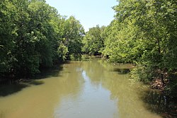
 View of the Conasauga River | |
 | |
| Physical characteristics | |
| Source | Cohutta Mountains |
| • coordinates | 34°51′57″N 84°35′32″W / 34.8657°N 84.5921°W |
| • elevation | ~ 2,400 feet (730 m)[1] |
| Mouth | Oostanaula River |
• location | Calhoun, GA |
• coordinates | 34°32′37″N 84°54′10″W / 34.5435°N 84.9027°W |
• elevation | ~ 620 feet (190 m)[2] |
| Length | 93 miles (150 km) |
| Basin size | 772 sq mi (2,000 km2) |
The Conasauga River is a river that runs through southeast Tennessee and northwest Georgia. The Conasauga River is 93 miles (150 km) long[3] and drains into the Oostanaula River, a tributary of the Coosa River and part of the watershed of the Gulf of Mexico. The river is home to over 90 species of fish and 25 surviving species of freshwater mussels.[4] Its watershed encompasses over 500,000 acres (2,000 km2) in two states, multiple counties, and two ecologically different regions.
Location
[edit]The Conasauga River is the most westerly trout water on public land in Georgia.[5] It is the only river in Tennessee that is not a part of the Mississippi River watershed.[citation needed]
The only road access to the Conasauga is found via Old GA 2, GA 2, and Carlton Petty Road. Access via foot trail is located on Forest Service road (FS) 64 in Betty Gap.[citation needed] Three other trails descend from the west off FS 17 to intersect the river trail.[citation needed] From south to north they are the Chestnut Lead, 2.0 miles (3.2 km), Tearbritches Trail, 4.0 miles (6.4 km), and Hickory Creek Trail, 3.0 miles (4.8 km).[citation needed] Primitive camping is allowed all along the river.[citation needed]
Natural information
[edit]At the core of the Conasauga watershed is the 35,268-acre (142.72 km2) Cohutta Wilderness, located in Fannin, Gilmer, and Murray counties in Georgia and Polk County in Tennessee. The United States Forest Service manages the area as part of the Chattahoochee National Forest and Cherokee National Forest. The preserve covers over 95,000 acres (380 km2) and contains approximately 15 miles (24 km) of the Conasauga.
The Conasauga River is home to more than 90 fish species,[4] including 10 federally listed species of fish and mussels.[6] Among these is the endemic, endangered Conasauga logperch (Percina jenkinsi).[7] Historically there were 42 species of freshwater mussels, however only 25 species still exist. It is estimated that only 1% of original population remains.[4][8] The waters yield established populations of rainbow trout and brown trout, with rainbows up to 20 inches (510 mm) and browns to 9 pounds (4.1 kg).[citation needed] The managed land is populated by white-tailed deer, wild hogs, black bears, and smaller animals.[citation needed]
Environmental problems
[edit]The Conasauga River is[4][8] a Category 1 priority watershed in Georgia's Unified Watershed Assessment [when?] and 18 miles (29 km) of the river and 54 miles (87 km) of the tributaries have been on Georgia's List of Impaired Waters for fecal, metal, toxic chemical, sediment, and nutrients.
Up to one-third of the summer flow taken in the vicinity of Dalton, Georgia is used for carpet production. The river has been contaminated with perfluorinated compounds used to make carpets stain-resistant.[9][10][11]
Name
[edit]"Conasauga" is a name derived from the Cherokee language meaning "grass".[12][13] According to the Geographic Names Information System, Conasauga River has also been known historically as:[14]
- Connasauga River
- Connesauga River
- Conne-san-ga River
- Slave River
- Jacks River now is the name of a tributary of the Conasauga.
See also
[edit]References
[edit]- ^ U.S. Geological Survey. Dyer Gap quadrangle, GA. 1:24,000. 7.5 Minute Series. Washington D.C.: USGS, 1988.
- ^ U.S. Geological Survey. Calhoun North quadrangle, GA. 1:24,000. 7.5 Minute Series. Washington D.C.: USGS, 1982.
- ^ U.S. Geological Survey. National Hydrography Dataset high-resolution flowline data. The National Map Archived 2016-06-30 at the Wayback Machine, accessed April 27, 2011
- ^ a b c d "Conasauga River Watershed Ecosystem Restoration Project". Chattahoochee-Oconee National Forests. USDA Forest Service. Archived from the original on 5 February 2007.
- ^ (2011) The Conasauga River Archived 2010-05-16 at the Wayback Machine Gorp.com, Great Outdoor Recreation Pages.
- ^ "Conasauga River Aquatic Species". Natural Resources Conservation Service. U.S. Department of Agriculture. Retrieved 22 February 2023.
- ^ "Conasauga logperch". U.S. Fish & Wildlife Service. Retrieved 22 February 2023.
- ^ a b "Conasauga River Watershed Planning" (PDF). Athens: Georgia Ecological Services, U.S. Fish and Wildlife Service. December 2009. Archived from the original (PDF) on 14 December 2018.
- ^ Fuchs, Erin and Pam Sohn: "Study finds high levels of stain-resistance ingredient in Conasauga River" Archived 2008-10-06 at the Wayback Machine Chattanooga Times Free Press. (February 10, 2008). Accessed October 26, 2008.
- ^ "The Chemical in The Conasauga". Georgia Public Broadcasting. n.d. Archived from the original on 6 November 2009. Retrieved 4 December 2009.
- ^ Konwick BJ, Tomy GT, Ismail N, Peterson JT, Fauver RJ, Higginbotham D, Fisk AT (October 2008). "Concentrations and patterns of perfluoroalkyl acids in Georgia, USA surface waters near and distant to a major use source". Environ. Toxicol. Chem. 27 (10): 2011–8. doi:10.1897/07-659.1. PMID 18419175.
- ^ Bright, William (2004). Native American Placenames of the United States. University of Oklahoma Press. p. 117. ISBN 978-0-8061-3598-4.
- ^ Krakow, Kenneth K. (1975). Georgia Place-Names: Their History and Origins (PDF). Macon, GA: Winship Press. p. 49. ISBN 0-915430-00-2.
- ^ U.S. Geological Survey Geographic Names Information System: Conasauga River
External links
[edit]- The Conasauga River - The Nature Conservancy no reference to Conasauga May 2016