This article needs additional citations for verification. (February 2024) |
Fiorentino
Fiurentêin (Romagnol) | |
|---|---|
 | |
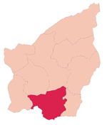
 Fiorentino's location in San Marino | |
| Coordinates: 43°54′38″N 12°27′20″E / 43.91056°N 12.45556°E | |
| Country | |
| Curazie | |
| Government | |
| • Capitano | Claudio Mancini (since 2020) |
| Area | |
• Total | 6.57 km2 (2.54 sq mi) |
| Elevation | 490 m (1,610 ft) |
| Population (May 2018) | |
• Total | 2,548[1] |
| Time zone | UTC+1 (CET) |
| • Summer (DST) | CEST |
| Postal code | 47897 |
| Climate | Cfb |
| Website | https://www.gov.sm/pub1/GovSM/Istituzioni-e-Forze/Giunte-di-Castello/Castello-di-Fiorentino.html |
Fiorentino (Romagnol: Fiurentêin) is one of the nine castelli of San Marino. It has 2,548 inhabitants (May 2018)[1] in an area of 6.57 km2 (2.54 sq mi).
Geography
[edit]It borders the San Marino municipalities Chiesanuova, San Marino, Borgo Maggiore, Faetano, and Montegiardino and the Italian municipalities Monte Grimano and Sassofeltrio.
Fiorentino contains three curazie: Capanne, Crociale, and Pianacci.[2][3]
History
[edit]Fiorentino was added due to the last territorial expansion of San Marino, in 1463. Evidence indicates a settlement existed on the site before Roman times.
Sport
[edit]Tre Fiori FC, one of the most successful clubs in Sammarinese football, is based in Fiorentino.
References
[edit]- ^ a b http://www.statistica.sm/contents/instance15/files/document/14101672tav_popolazione_.pdf [bare URL PDF]
- ^ Rattini, Maurizio; Venturini, Gian Carlo; Volpinari, Antonio L. (21 March 1997). "Regolamento per la disciplina della campagna elttorale". Elezioni (in Italian). Archived from the original on 5 August 2009. Retrieved 14 February 2020.
- ^ "Fiorentino". San Marino Web (in Italian). Retrieved 9 February 2024.
External links
[edit]![]() Media related to Fiorentino at Wikimedia Commons
Media related to Fiorentino at Wikimedia Commons
43°54′38″N 12°27′20″E / 43.91056°N 12.45556°E


