| Gascoyne | |
|---|---|
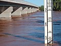
 The Gascoyne riverbed near Carnarvon | |
 | |
| Etymology | Captain John Gascoyne RN, son of Bamber Gascoyne |
| Location | |
| Country | Australia |
| State | Western Australia |
| Region | Gascoyne |
| City | Carnarvon |
| Physical characteristics | |
| Source | Collier Range |
| • location | Three Rivers Station |
| • coordinates | 24°39′8″S 119°44′58″E / 24.65222°S 119.74944°E |
| • elevation | 514 m (1,686 ft) |
| 2nd source | Gascoyne River (Middle) |
| • location | west of Beyondie Lakes |
| • coordinates | 25°20′42″S 119°38′53″E / 25.34500°S 119.64806°E |
| 3rd source | Gascoyne River (South) |
| • location | near the Doolgunna homestead |
| • coordinates | 25°41′45″S 119°13′17″E / 25.69583°S 119.22139°E |
| Source confluence | Gascoyne River (North) |
| • coordinates | 25°18′29″S 119°6′42″E / 25.30806°S 119.11167°E |
| Mouth | Indian Ocean |
• location | Shark Bay |
• coordinates | 24°52′14″S 113°36′57″E / 24.87056°S 113.61583°E |
• elevation | 0 m (0 ft) |
| Length | 865 km (537 mi) |
| Basin size | 76,254 km2 (29,442 sq mi) |
| Discharge | |
| • location | mouth |
| Basin features | |
| Tributaries | |
| • left | Landor River, Thirty One River, Lyons River |
| • right | Thomas River |
| Natural pools | Tibingoona Pool; Bibbingoona Pool; Nungamarra Pool; Mibbley Pool; Mutherbukin Pool; Beelu Pool; Bilyarra Pool; Piddendoora Pool; and Gnardune Pool |
| [1][2][3][4][5] | |


The Gascoyne River is a river in the Gascoyne region of Western Australia. At 865 kilometres (537 mi), it is the longest river in Western Australia.[3]
Description
[edit]The Gascoyne River comprises three branches in its upper reaches. Draining the Collier Range, the river rises as the Gascoyne River (North Branch) on Three Rivers Station near the Great Northern Highway, 100 kilometres (62 mi) northeast of Peak Hill and flows for approximately 125 kilometres (78 mi). The Gascoyne River (Middle Branch) rises west of Beyondie Lakes, east of Kumarina and east of the Great Northern Highway and flows for approximately 15 kilometres (9.3 mi). The Gascoyne River (South Branch) rises near the Doolgunna homestead and flows for approximately 15 kilometres (9.3 mi).
The Gascoyne flows generally west by south-west and is joined by 36 tributaries, including the Lyons River, Landor River, Thomas River, and numerous other creeks and gullies. The two main rivers, the Gascoyne and Lyons together provide a catchment area of 68,326 square kilometres (26,381 sq mi) that lies entirely to the east of the Kennedy Ranges and extends some 480 kilometres (298 mi) inland. The river reaches its mouth as it flows into Shark Bay and the Indian Ocean at Carnarvon.[4] The river descends 514 metres (1,686 ft) over its 865-kilometre (537 mi) course.[2]
It is said to be an "upside-down river", because it flows for about 120 days of the year and below the dry river bed for the remainder of the year. It is, in effect, a huge water storage system with the river aquifer lying below the desert sands.
The Gascoyne flows through sparsely vegetated countryside which is used mainly for gold mining, and sheep and cattle grazing. It includes many permanent pools that are valuable to both stock and native species. Some of the main pools located along the river include Tibbingoona Pool, Mutherbokin Pool and Mibbley Pool.[2]
History
[edit]The extensive catchment of the Gascoyne River means that it flows through the country of a number of Aboriginal peoples, the principal ones being the Baiyungu, Yinggarda, Thudgari, Malgana and Wajarri.[6]
The first Europeans to see the river, on 4 March 1839, were a party led by the explorer Lieutenant George Grey, who named the river after a friend, Captain John Gascoyne RN,[7] son of Bamber Gascoyne, a Lord Commissioner of the Admiralty. Captain Gascoyne was a committee member of the London-based Western Australian Missionary Society and a member of the London Association for the Protection of the Interests of the Colony.[8]
From mid 1909 to early 1913, the area had three dry years, with the Gascoyne River not running for any of that time, and Carnarvon had water supply problems as a result.[9]
Floods
[edit]The most severe flooding of the Gascoyne River occurred in December 2010.[10] Triggered by record-breaking rainfall, amounting to over 6,000 percent of the monthly mean, 313.6 millimetres (12.35 in) and 5 millimetres (0.20 in) respectively, in just four days, the floods caused widespread damage in the region. The water reached record levels at three stations along the river, cresting at 15.53 metres (51 ft) near Fishy Pool.
Evacuation orders were issued for several towns affected by rising waters. The most substantial impact was felt in Carnarvon where entire homes were washed away. Following the disaster, emergency supplies and funds were distributed to affected residents to aid in restoring their livelihoods. Though no people died, an estimated two thousand head of cattle perished, and damage was estimated at A$100 million.[11] The size of the flood, and the region it affected, created widespread problems.[12]
In March 2015, Cyclone Olwyn affected the Gascoyne River and caused the most severe flooding since 2010.[13]
Gallery
[edit]-
 Rocky Pool, Gascoyne River, April 2006
 -
 Gascoyne River in flood, April 2006
 -
 Dry Gascoyne riverbed, July 2005


See also
[edit]References
[edit]- ^ "History of river names – F". Western Australian Land Information Authority. Archived from the original on 19 April 2021. Retrieved 4 September 2011.
- ^ a b c "Map of Gascoyne River, WA". Bonzle Digital Atlas. 2008. Retrieved 23 September 2015.
- ^ a b "Interesting facts about Western Australia". Landgate. Western Australian Land Information Authority. Retrieved 23 September 2015.
- ^ a b "Historical town name: Gascoyne Junction". Landgate. Western Australian Land Information Authority. Archived from the original on 29 March 2015. Retrieved 23 September 2015.
- ^ Tille, Peter (December 2006). "Soil-landscapes of Western Australia's Rangelands and Arid Interior" (PDF). Resource Management Technical Report (313): 13. Retrieved 9 May 2012.
- ^ "Aboriginal Culture". Gascoyne Development Commission. Retrieved 15 March 2024.
- ^ Grey, George (1841). Journals of two expeditions of discovery in North-West and Western Australia, during the years 1837, 38, and 39, describing many newly discovered, important, and fertile districts, with observations on the moral and physical condition of the aboriginal inhabitants, etc. etc. Vol. 1. London: T. and W. Boone. p. 349. Retrieved 17 March 2012.
- ^ "From a private correspondent". The Perth Gazette and Western Australian Journal. 2 July 1836. pp. 720–721. Retrieved 9 May 2012.
- ^ "River past Doorawarrah". The Northern Times. Carnarvon, Western Australia. 1 February 1913. p. 5. Retrieved 17 December 2013 – via National Library of Australia.
- ^ Macqueen, Cristy-Lee (4 February 2011). "Survival, recovery and Aussie spirit-Gascoyne locals share their stories". ABC News. Australia. Archived from the original on 9 July 2019. Retrieved 16 February 2011.
- ^ "Massive damage from worst ever floods". ABC News. Australia. 21 December 2010. Retrieved 23 September 2015.
- ^ "Government warned about flood potential". ABC News. Australia. 21 December 2010. Retrieved 23 September 2015.
- ^ "Health fears as Carnarvon counts the cost of Tropical Cyclone Olwyn". Perth Now. 15 March 2014. Archived from the original on 15 March 2015. Retrieved 22 March 2015.
Rivers of Western Australia | |
|---|---|
| Rivers of the Gascoyne region | |
| Rivers of the Goldfields–Esperance region | |
| Rivers of the Great Southern region | |
| Rivers of the Kimberley region |
|
| Rivers of the Mid West region | |
| Rivers of the Peel and Perth regions | |
| Rivers of the Pilbara region | |
| Rivers of the South West region | |
| Rivers of the Wheatbelt region | |
| International | |
|---|---|
| National | |