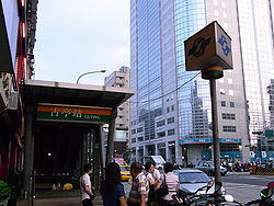
Guting
古亭區 Kuting | |
|---|---|
| Guting District | |
 Guting MRT Station, Today | |
 | |
| Country | Republic of China (Taiwan) |
| Region | Southwestern Taipei |
| Divisions | List
|
| Area | |
• Total | 6.7 km2 (2.6 sq mi) |
| Population (1989) | |
• Total | 186,257[1] |
| Postal code | 107 |
Guting District (Chinese: 古亭區; pinyin: Gǔtíng Qū) was a district in Taipei, Taiwan, located in the southwestern part of Taipei.
History
[edit]The name “Guting” is derived from the ancient place name Ku-ting (Min Nan Chinese: Kóo-tîng).
After Taihoku City was established in 1920, in 1922, the Japanese Colonial Government carried out the Correction of Villages' Name (町名改正, chōmei kaisei). There were 11 villages (町, chō) in the area of later Guting District: Shineichō (新榮町), Chitosechō (千歳町), Kodamachō (兒玉町), Sakumachō (佐久間町), Nanmonchō (南門町), Ryūkōchō (龍口町), Babachō (馬場町), Kawabatachō (川端町), Koteichō (古亭町), Suidōchō (水道町) and Tomitachō (富田町).
In 1946, the Taiwan Province Administrative Official Public Ministry (臺灣省行政長官公署) made those villages incorporated as Guting District.
In 1990, 16 districts in Taipei City were consolidated into the current 12 districts. Most of Guting District were merged into Zhongzheng District (中正區) along with Chengzhong District (城中區), moreover the rest were annexed into Daan District (大安區) and Wanhua District (萬華區).
Geography
[edit]Guting District bordered Chengzhong District (城中區) to the north, Daan District (大安區) to the east, Shuangyuan District (雙園區) to the west and Longshan District (龍山區) to the northwest. The Xindian River (新店溪) run by its south.
Education and Medical Institutions
[edit]Universities and Colleges
[edit]High school
[edit]Medical Institutions
[edit]- Postal Hospital[2]
- Women's and Children's Hospital (Fuyou Hospital)[3][4]
- Heping Hospital[3][4]
- Tri-Service General Hospital
Government Institutions
[edit]- Central Bank of the Republic of China
- Ministry of Finance of the Republic of China
- Ministry of Economic Affairs of the Republic of China
- Council of Agriculture of the Republic of China
- Taiwan Tobacco and Wine Monopoly Bureau
- Bureau of Labor Insurance
Places of Interest
[edit]- Youth Park[5]
- Taipei Botanical Garden
- National Museum of History
- Taipei City Children's Museum of Transportation[6][7]
References
[edit]- ^ "台北市70年以後各行政區戶數、人口數". 台北市民政局. Archived from the original on 2007-12-06. Retrieved 2008-07-22.
- ^ "郵政醫院". postal.com.tw. Retrieved 2018-01-27.
- ^ a b 婦幼醫院
- ^ a b "臺北市立聯合醫院和平婦幼院區 ─ 沿革". tpech.gov.taipei. Retrieved 2018-01-27.
- ^ 青年公園
- ^ zh:臺北市客家文化主題公園
- ^ 臺北市客家文化主題公園. "歷史緣起 - 臺北市客家文化主題公園 – Historic Origins - Taipei City Hakka Cultural Park". ssl.thcp.org.tw. Retrieved 2018-01-27.