This article needs to be updated. The reason given is: outdated info. (December 2022) |
Kilmurry-Negaul
Cill Mhuire na nGall | |
|---|---|
Civil parish | |
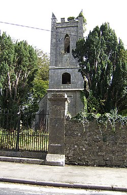
 Disused church at Kilmurry by the R462 Sixmilebridge road | |
| Coordinates: 52°46′40″N 8°46′58″W / 52.7778°N 8.7828°W | |
| Country | Ireland |
| Province | Munster |
| County | County Clare |
| Elevation | 45 m (148 ft) |
| Population | 280 |
| (Kilmurry village) | |
| Time zone | UTC+0 (WET) |
| • Summer (DST) | UTC-1 (IST (WEST)) |
| Irish Grid Reference | Q807509 |
Kilmurry-Negaul (Irish: Cill Mhuire na nGall[a]) is a civil parish and a village in County Clare, Ireland.
Location
[edit]Kilmurry-Negaul is a civil parish containing a village with the name Kilmurry. It was within the barony of Tulla Upper, but as of 1845 had recently been transferred to the barony of Bunratty Lower. It is 3.5 by 1.5 miles (5.6 by 2.4 km) and covers 2,917 acres (1,180 ha). The village of Kilmurry is 2.5 miles (4.0 km) north of Sixmilebridge on the road to Quin.[3] There is a large tract of fine arable country of a light limestone where the parishes of Quinn, Clonlea and Kilmurry-Negral meet.[4]
Antiquity
[edit]The name Kilmurry means "Church of the Virgin Mary", but originally the parish may have been dedicated to an Irish saint. A holy well near the old church is dedicated to Saint Tobar Faoile. The castle of Rossroe, well-preserved in 1897, belonged to Fineen, son of Loghlen MacNamara, in 1580. The castle of Drumullan was in 1580 the property of Covea, son of Mahone MacNamara.[5] The parish lay in MacNamara territory, and the families of this powerful sect would not abandon the Catholic faith.[6]
During the reign of King William III of England (1689–1702) John Lawson, an Englishman, was given the rectories of Quin, Tulloo, Cluony, Dowry, Templemaley, Kilraghtis and Kilmurry-Negaul.[7] Opposite the record of this appointment was the note, "No cure served at present; noe church in repaire; the country all wast." These had been seven of the best parishes in the county.[6]
On 18 March 1790 the vicarages of Kilseily, Bunratty, Clonlea, Clonloghan, Finogh, Kilconry, Killuran, Kilfinaghty, Kilmurrynegaul, Kilnoe and Tomfinlough were episcopally united in the Church of Ireland.[8] In 1810 the Church of Ireland rectory of Kilmurraynegaul was valued in the King's books at £0.6.8 sterling. It was one of the parishes that made up the Union of Kilseily.[9] As of 1837 the civil parish was part of the Catholic union of Sixmilebridge.[10]
The population was 980 in 1821 and had fallen to 628 in 1831.[11] In 1841 the population had risen to 699 in 101 houses.[3] The old burial ground in the village had the ruins of an old church in 1837.[10] By 1897 all traces of the church had gone, but the graveyard surrounding it remained in use.[5]
Townlands
[edit]The townlands are Cloonmunnia, Cragroe, Drumullan, Kilcornan, Kilkishen, Kilkishen Demesne, Kilmurry, Knocknalappa, Rosroe, Shandangan East and Shandangan West.[12]
References
[edit]Notes
Citations
- ^ "Kilmurry (Ireland) Census Town". City Population. Retrieved 26 July 2021.
- ^ Cill Mhuire na nGall, Placenames Database of Ireland.
- ^ a b Parliamentary Gazeteer of Ireland 1846, p. 522.
- ^ Lewis 1837b, p. 332.
- ^ a b Frost 1897.
- ^ a b White 1893, p. 290.
- ^ Dwyer 1878, p. 426.
- ^ Carlisle 1810, p. 505.
- ^ Carlisle 1810, p. 497.
- ^ a b Lewis 1837.
- ^ Accounts and Papers 1833, p. 20.
- ^ Map of Kilmurry-Negaul Parish showing Townlands.
Sources
- Accounts and Papers: 17 Volumes. 1833.
- Carlisle, Nicholas (1810). A Topographical Dictionary of Ireland: Exhibiting the Names of the Several Cities, Towns, Parishes, and Villages ... Collected from the Most Authentic Documents, and Arranged in Alphabetical Order. Being a Continuation of the Topography of the United Kingdom of Great Britain and Ireland. W. Miller. Retrieved 3 April 2014.
- "Cill Mhuire na nGall". Placenames Database of Ireland. Retrieved 10 April 2014.
- Dwyer, Philip (1878). The Diocese of Killaloe from the Reformation to the Close of the Eighteenth Century: With an Appendix. Hodges, Foster, and Figgis. p. 426. Retrieved 3 April 2014.
- Frost, James (1897). "Ui Caisin - Kilmurry Parish". The History and Topography of the County of Clare. Retrieved 3 April 2014.
- Lewis, Samuel (1837). "Kilmurry-Negaul". County Clare: A History and Topography. Retrieved 3 April 2014.
- Lewis, Samuel (1837b). A Topographical Dictionary of Ireland. Lewis. Retrieved 3 April 2014.
- "Map of Kilmurry-Negaul Parish showing Townlands". Clare County Library. Retrieved 3 April 2014.
- Parliamentary Gazetteer of Ireland: Adapted to the New Poor-law, Franchise, Municipal and Ecclesiastical Arrangements, and Compiled with a Special Reference to the Lines of Railroad and Canal Communication, as Existing in 1814-45. A. Fullarton and Company. 1846. Retrieved 3 April 2014.
- White, Patrick (1893). History of Clare and the Dalcassian Clans of Tipperary, Limerick, and Galway ...: With an Ancient and a Modern Map. M.H. Gill & Son. Retrieved 3 April 2014.
