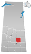
Lestock | |
|---|---|
| Coordinates: 51°18′42″N 103°58′46″W / 51.31167°N 103.97944°W | |
| Country | |
| Province | |
| Region | Central |
| Census division | 10 |
| Rural municipality | Kellross No. 247 |
| Incorporated (village)[1] | April 17, 1912 |
| Dissolved (special service area)[2] | September 1, 2017 |
| Area | |
• Total | 0.87 km2 (0.34 sq mi) |
| Population (2016) | |
• Total | 95 |
| • Density | 109.3/km2 (283/sq mi) |
| Time zone | UTC-6 (CST) |
| Postal code | S0A 2G0 |
| Area code | 306 |
| Highways | |
| Railways | Canadian National Railway |
| Website | Village of Lestock |
Lestock is a special service area within the Rural Municipality of Kellross No. 247, Saskatchewan, Canada that held village status prior to September 2017. Lestock had a population of 95 in the 2016 Canada Census, a -24.0% decline from 125 in the 2011 Canada Census.
The community was named after John Lestock Reid, a surveyor for the railway.[3]
History
[edit]Lestock was incorporated as a village on April 17, 1912.[1] It restructured on September 1, 2017, relinquishing its village status in favour of becoming a special service area under the jurisdiction of the Rural Municipality of Kellross No. 247.[2]
Demographics
[edit]Canada census – Lestock, Saskatchewan community profile
| 2016 | 2011 | |
|---|---|---|
| Population | 95 (-24.0% from 2011) | 125 (-9.4% from 2006) |
| Land area | 0.87 km2 (0.34 sq mi) | 0.87 km2 (0.34 sq mi) |
| Population density | 187.7/km2 (486/sq mi) | 182.4/km2 (472/sq mi) |
| Median age | 56.8 (M: 61.2, F: 53.0) | 51.7 (M: 52.8, F: 50.0) |
| Private dwellings | 98 (total) | 76 (total) |
| Median household income |
See also
[edit]References
[edit]- ^ a b "Urban Municipality Incorporations" (PDF). Saskatchewan Ministry of Government Relations. p. 8. Archived from the original on October 15, 2014. Retrieved October 13, 2019.
- ^ a b "Restructuring of the Village of Lestock" (PDF). The Saskatchewan Gazette. September 8, 2017. pp. 1718–1723. Retrieved October 12, 2019.
- ^ "Lesstock, Saskatchewan profile". epodunk.com. Retrieved September 11, 2010.
- ^ "2016 Community Profiles". 2016 Canadian census. Statistics Canada. August 12, 2021. Retrieved March 15, 2017.
- ^ "2011 Community Profiles". 2011 Canadian census. Statistics Canada. March 21, 2019. Retrieved October 14, 2012.
- ^ "2006 Community Profiles". 2006 Canadian census. Statistics Canada. August 20, 2019.
- ^ "2001 Community Profiles". 2001 Canadian census. Statistics Canada. July 18, 2021.


