This article needs additional citations for verification. (May 2019) |
Munshiganj Sadar
মুন্সীগঞ্জ সদর | |
|---|---|
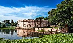
 Idrakpur Fort | |
 | |
| Coordinates: 23°27′30″N 90°32′30″E / 23.4583°N 90.5417°E | |
| Country | |
| Division | Dhaka |
| District | Munshiganj |
| Area | |
• Total | 218.07 km2 (84.20 sq mi) |
| Population | |
• Total | 436,018 |
| • Density | 2,000/km2 (5,200/sq mi) |
| Time zone | UTC+6 (BST) |
| Postal code | 1500[2] |
| Area code | 0691[3] |
| Website | sadar |
Munshiganj Sadar (Bengali: মুন্সীগঞ্জ সদর) is an upazila of Munshiganj District[4] in the Division of Dhaka, Bangladesh.
History
[edit]In 1971
[edit]On 29 March 1971, days after the start of the Bangladesh Liberation War, people of Munshiganj raided the armoury and captured arms and ammunition, which they used to resist the Pakistan Army. The people of Narayanganj and Munshiganj together resisted an attack of the Pakistan Army on 31 March. The Pakistan Army killed some youths at Kewar on 14 May.[5]
Demographics
[edit]According to the 2011 Census of Bangladesh, Munshiganj Sadar Upazila had 81,146 households and a population of 383,263. 82,488 (21.52%) were under 10 years of age. Munshiganj Sadar had a literacy rate (age 7 and over) of 55.17%, compared to the national average of 51.8%, and a sex ratio of 970 females per 1000 males. 138,205 (36.06%) lived in urban areas.[7][8]
As of the 1991 Bangladesh census, Munshiganj district, formerly a subdivision under Dhaka district, was established in 1984. It consists of 6 upazilas, 67 union parishads, 662 mouzas, 906 villages, 18 wards, 73 mahallas and 2 municipalities.[9]
Administration
[edit]Munshiganj Sadar Upazila is divided into Mirkadim Municipality, Munshiganj Municipality, and nine union parishads: Adhara, Bajrajogini, Banglabazar, Charkewar, Mohakali, Mollakandi, Panchashar, Rampal, and Shiloy. The union parishads are subdivided into 94 mauzas and 196 villages.[7]
Mirkadim Municipality and Munshiganj Municipality are each subdivided into 9 wards.[7]
Education
[edit]There are six colleges in the upazila: Government Haraganga College, Mirkadim Hazi Amzad Ali (Degree) College, Munshigonj College, Munshigonj Government Mohila College, President Prof. DR. Iajuddin Ahmed Residential Model School & College, and Rampal College.[10]
According to Banglapedia, notable secondary schools include A. V. G. M. Government Girls' High School, founded in 1892, Bajrajogini J. K. High School (1883), Basirannesa High School (1972), Rikaby Bazar GIRLS' High School, Binodpur Ramkumar High School (1919), Edrakpur High School (1970), K. K. Government Institution (1942), Munshiganj M. L. High School (1885), and Rampal N. B. M. High School (1933) Mirkadim Hazi Amzad Ali High School.[4]
Notable residents
[edit]- A M Nurul Islam, civil servant, attended Munshiganj High School.[11]
See also
[edit]References
[edit]- ^ National Report (PDF). Population and Housing Census 2022. Vol. 1. Dhaka: Bangladesh Bureau of Statistics. November 2023. p. 398. ISBN 978-9844752016.
- ^ "Bangladesh Postal Code". Dhaka: Bangladesh Postal Department under the Department of Posts and Telecommunications of the Ministry of Posts, Telecommunications and Information Technology of the People's Republic of Bangladesh. 20 October 2024.
- ^ "Bangladesh Area Code". China: Chahaoba.com. 18 October 2024.
- ^ a b Ratantanu Ghosh (2012), "Munshiganj Sadar Upazila", in Sirajul Islam and Ahmed A. Jamal (ed.), Banglapedia: National Encyclopedia of Bangladesh (Second ed.), Asiatic Society of Bangladesh
- ^ Ratantanu Ghosh (2012). "Munshiganj District". In Sirajul Islam; Ahmed A. Jamal (eds.). Banglapedia: National Encyclopedia of Bangladesh (Second ed.). Asiatic Society of Bangladesh.
- ^ Population and Housing Census 2022 - District Report: Munshiganj (PDF). District Series. Dhaka: Bangladesh Bureau of Statistics. June 2024. ISBN 978-984-475-282-5.
- ^ a b c "Bangladesh Population and Housing Census 2011 Zila Report – Munshiganj" (PDF). bbs.gov.bd. Bangladesh Bureau of Statistics.
- ^ "Community Tables: Munshiganj district" (PDF). bbs.gov.bd. Bangladesh Bureau of Statistics. 2011.
- ^ "Population Census Wing, BBS". Archived from the original on 2005-03-27. Retrieved November 10, 2006.
- ^ "List of Colleges". Department of Secondary and Higher Education. Retrieved 6 September 2020.
- ^ Imam, Shah Husain (20 October 2017). "Nurul Islam Anu as I knew him". The Daily Star.
