Nieuwe Niedorp | |
|---|---|
Village | |
 Marina of Nieuwe Niedorp | |
 Coat of arms | |
 Nieuwe Niedorp Location in the Netherlands  Nieuwe Niedorp Location in the province of North Holland in the Netherlands | |
| Coordinates: 52°44′29″N 4°54′2″E / 52.74139°N 4.90056°E | |
| Country | Netherlands |
| Province | North Holland |
| Municipality | Hollands Kroon |
| Area | |
• Total | 10.82 km2 (4.18 sq mi) |
| Elevation | −0.5 m (−1.6 ft) |
| Population (2021)[1] | |
• Total | 2,255 |
| • Density | 210/km2 (540/sq mi) |
| Time zone | UTC+1 (CET) |
| • Summer (DST) | UTC+2 (CEST) |
| Postal code | 1733[1] |
| Dialing code | 0226 |
Nieuwe Niedorp (West Frisian: Naaie Nierup) is a village in the Dutch province of North Holland. It is a part of the municipality of Hollands Kroon, and lies about 9 kilometres (5.6 mi) northeast of Heerhugowaard.
History
[edit]The village was first mentioned in 1289 as Niewenniedorp, and means "new new village". The extra Nieuwe (new) was added to distinguish from Oude Niedorp.[3] Nieuwe Niedorp developed in the Middle Ages as a peat excavation area.[4]
The Catholic Our Lady of Immaculate Conception Church was built between 1905 and 1906 as part of a U-shaped Franciscan monastery.[4] The Dutch Reformed Fenix church from 1966, has a leaning church tower.[5]
Nieuwe Niedorp was home to 534 people in 1840.[5] It was a separate municipality until 1970, when it merged with Oude Niedorp and Winkel.[6] In 2012, it became part of the municipality of Hollands Kroon.[5]
Notable people
[edit]- Dirck Pietersz van Nierop 1540-1610
- Dirck Rembrantsz van Nierop 1610-1682
- Pieter Rembrantsz van Nierop 1640-1708
- Elisabeth van der Woude 1657-1698
Gallery
[edit]-
 Mayor's house
 -
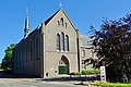 Monastery with church
 -
 Village house
 -
 House in Nieuwe Niedorp


See also
[edit]References
[edit]- ^ a b c "Kerncijfers wijken en buurten 2021". Central Bureau of Statistics. Retrieved 30 April 2022.
two entries
- ^ "Postcodetool for 1733AA". Actueel Hoogtebestand Nederland (in Dutch). Het Waterschapshuis. Retrieved 30 April 2022.
- ^ "Nieuwe-Niedorp - (geografische naam)". Etymologiebank (in Dutch). Retrieved 30 April 2022.
- ^ a b Ronald Stenvert & Saskia van Ginkel-Meester (2006). "Nieuwe Niedorp" (in Dutch). Zwolle: Waanders. Retrieved 30 April 2022.
- ^ a b c "Nieuwe Niedorp". Plaatsengids (in Dutch). Retrieved 30 April 2022.
- ^ Ad van der Meer and Onno Boonstra, Repertorium van Nederlandse gemeenten, KNAW, 2011.
This North Holland location article is a stub. You can help Wikipedia by expanding it. |