| Ninnescah River | |
|---|---|
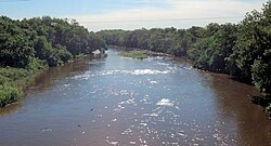
 Ninnescah River at Peck, Kansas | |
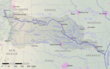
 Map of the Arkansas River watershed including the Ninnescah River | |
| Location | |
| Country | United States |
| State | Kansas |
| Physical characteristics | |
| Source confluence | |
| • location | Sedgwick County, Kansas |
| • coordinates | 37°34′05″N 97°42′19″W / 37.56806°N 97.70528°W |
| • elevation | 1,302 ft (397 m) |
| Mouth | Arkansas River |
• location | Sumner County, Kansas |
• coordinates | 37°19′17″N 97°09′59″W / 37.32139°N 97.16639°W[1] |
• elevation | 1,152 ft (351 m) |
| Length | 56 mi (90 km) |
| Basin size | 2,129 sq mi (5,510 km2) |
| Discharge | |
| • location | USGS 07145500 near Peck, KS[2] |
| • average | 522 cu ft/s (14.8 m3/s) |
| • minimum | 0.2 cu ft/s (0.0057 m3/s) |
| • maximum | 33,700 cu ft/s (950 m3/s) |
| Basin features | |
| Tributaries | |
| • left | North Fork Ninnescah River |
| • right | South Fork Ninnescah River |
| Watersheds | Ninnescah-Arkansas- Mississippi |
The Ninnescah River is a river in the central Great Plains of North America. Its entire 56.4-mile (90.8 km) length lies within the U.S. state of Kansas. It is a tributary of the Arkansas River.[3]
Geography
[edit]The Ninnescah River originates in the Wellington Lowlands of south-central Kansas. It is formed in southwestern Sedgwick County by the confluence of the North Fork Ninnescah River and the South Fork Ninnescah River. From there, it flows southeast into the Arkansas River Lowlands. It empties into the Arkansas River roughly 3 miles (4.8 km) north of Oxford, Kansas in eastern Sumner County.[4]
See also
[edit]References
[edit]- ^ "Ninnescah River". Geographic Names Information System. United States Geological Survey, United States Department of the Interior. Retrieved 2015-10-19.
- ^ "Water-Data Report 2013 - 07145500 Ninnescah River Near Peck, KS" (PDF). U.S. Geological Survey. Retrieved 2015-10-19.
- ^ U.S. Geological Survey. National Hydrography Dataset high-resolution flowline data. The National Map, accessed March 29, 2011
- ^ "2003-2004 Official Transportation Map" (PDF). Kansas Department of Transportation. Retrieved 2015-10-19.
- Kansas: a cyclopedia of state history, embracing events, institutions, industries, counties, cities, towns, prominent persons. Standard Pub. Co. Chicago : 1912. Volume II. Page 370.
External links
[edit]- U.S. Geological Survey Geographic Names Information System: Ninnescah River
- Continuous Real-Time Water-Quality Monitoring and Regression Analysis to Compute Constituent Concentrations and Loads in the North Fork Ninnescah River Upstream from Cheney Reservoir, South-Central Kansas, 1999-2012 United States Geological Survey