Pearce, Arizona | |
|---|---|
| Coordinates: 31°54′18″N 109°49′14″W / 31.90500°N 109.82056°W | |
| Country | United States |
| State | Arizona |
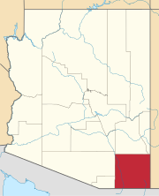
| County | Cochise |
| Settled | 1894 |
| Zip code | 85625 |

Pearce, Arizona, and Sunsites, Arizona, are adjacent unincorporated communities in the Sulphur Springs Valley of Cochise County, Arizona, United States. The two communities are often referred to as Pearce–Sunsites, Pearce/Sunsites, or Pearce Sunsites.[1][2]
Pearce is located between the Cochise Stronghold,[3] Chiricahua National Monument,[4] and the winter Sandhill Crane refuge of Whitewater Draw[5] making it popular for birders, history buffs, hikers, and climbers alike. At 4,400 feet of elevation, the area is also known for its milder summers which make it ideal for quality grapes and vineyards (recognized as an American Viticultural Area).[6]
Pearce is best known as a historic ghost town. Sunsites, founded in 1961, adjoins Pearce, and the Sunizona and Richland developments are nearby. All of these communities share the Pearce, Arizona post office and ZIP code, 85625.[7] The 85625 ZIP Code Tabulation Area, which includes the four communities named plus a large surrounding rural area, had a population of 2104 at the 2000 census.[8] and 1983 in the 2010 census.[9] The Pearce–Sunsites economy is based on retirees and tourism.[1]
Fittsburg was the site of the Commonwealth Mine and is located about one mile east of Pearce.[10]
History
[edit]Pearce is a mining ghost town named for Cornishman James Pearce, miner and cattleman, who discovered gold nearby at what became the Commonwealth Mine in 1894. The Pearce Post Office was established on March 6, 1896. The railroad station opened in 1903. By 1919, Pearce had a population of 1,500. The town declined in the 1930s and became almost a ghost town in the late 1940s when the mine closed for the last time.
The Commonwealth Mine became one of Arizona's major silver producers. Over 1,000,000 tons of ore were produced from 1895 to 1942. There are about 20 miles of underground workings.[11] The mine produced about $8 million worth of silver and $2.5 million in gold at a time when silver was priced around 50 cents an ounce, and gold was $20 an ounce.[12]
Sunsites was established in the 1950s and 1960s by New York lawyer Joseph Timan and his Horizon Land Company.[13]
Historic sites
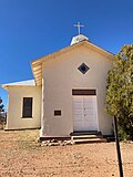
[edit]Pearce is the home of two properties on the National Register of Historic Places. The Old Pearce General Store opened in 1896. The store remained open as a tourist attraction after Pearce (almost) died, and remains open in 2009. Our Lady of Victory Catholic Church was added to the National Register of Historic Places in 2004. There are a number of other historic structures still extant in and around Pearce, some still in use, others in ruins.[10]
Climate
[edit]Pearce has a cold semi-arid climate (Köppen: BSk) with cool winters and hot summers.
| Climate data for Pearce–Sunsites, Arizona (1991–2020 normals, extremes 1913–1918, 1950–1980, 1988–present) | |||||||||||||
|---|---|---|---|---|---|---|---|---|---|---|---|---|---|
| Month | Jan | Feb | Mar | Apr | May | Jun | Jul | Aug | Sep | Oct | Nov | Dec | Year |
| Record high °F (°C) | 82 (28) |
87 (31) |
90 (32) |
97 (36) |
103 (39) |
109 (43) |
108 (42) |
104 (40) |
102 (39) |
98 (37) |
89 (32) |
79 (26) |
109 (43) |
| Mean daily maximum °F (°C) | 60.0 (15.6) |
63.7 (17.6) |
70.4 (21.3) |
77.5 (25.3) |
85.8 (29.9) |
94.8 (34.9) |
92.6 (33.7) |
90.7 (32.6) |
87.7 (30.9) |
80.0 (26.7) |
68.8 (20.4) |
59.3 (15.2) |
77.6 (25.3) |
| Daily mean °F (°C) | 44.6 (7.0) |
47.9 (8.8) |
53.4 (11.9) |
59.6 (15.3) |
67.7 (19.8) |
77.1 (25.1) |
78.9 (26.1) |
77.2 (25.1) |
72.5 (22.5) |
62.9 (17.2) |
52.2 (11.2) |
44.4 (6.9) |
61.5 (16.4) |
| Mean daily minimum °F (°C) | 29.1 (−1.6) |
32.1 (0.1) |
36.5 (2.5) |
41.7 (5.4) |
49.5 (9.7) |
59.4 (15.2) |
65.1 (18.4) |
63.6 (17.6) |
57.4 (14.1) |
45.8 (7.7) |
35.5 (1.9) |
29.4 (−1.4) |
45.4 (7.4) |
| Record low °F (°C) | 4 (−16) |
2 (−17) |
11 (−12) |
22 (−6) |
26 (−3) |
41 (5) |
52 (11) |
50 (10) |
39 (4) |
22 (−6) |
12 (−11) |
−8 (−22) |
−8 (−22) |
| Average precipitation inches (mm) | 0.85 (22) |
0.75 (19) |
0.55 (14) |
0.19 (4.8) |
0.23 (5.8) |
0.56 (14) |
2.58 (66) |
2.86 (73) |
1.47 (37) |
0.68 (17) |
0.67 (17) |
0.80 (20) |
12.19 (310) |
| Average snowfall inches (cm) | 0.7 (1.8) |
0.2 (0.51) |
0.1 (0.25) |
0.0 (0.0) |
0.0 (0.0) |
0.0 (0.0) |
0.0 (0.0) |
0.0 (0.0) |
0.0 (0.0) |
0.0 (0.0) |
0.2 (0.51) |
0.0 (0.0) |
1.2 (3.0) |
| Average precipitation days (≥ 0.01 inch) | 4.2 | 4.6 | 3.2 | 1.6 | 2.0 | 2.5 | 9.4 | 10.8 | 5.5 | 3.2 | 3.1 | 4.5 | 54.6 |
| Average snowy days (≥ 0.1 inch) | 0.0 | 0.0 | 0.0 | 0.0 | 0.0 | 0.0 | 0.0 | 0.0 | 0.0 | 0.0 | 0.1 | 0.2 | 0.3 |
| Source: NOAA[14][15] | |||||||||||||
Notable people
[edit]- Burt Alvord, late 19th-century lawman in Pearce
- Daniel Barringer (geologist), part owner of Commonwealth Mine
- Bill Downing, a notorious late 19th-century outlaw
- Edward Landers Drew, Pinal County deputy sheriff buried in the Pearce Cemetery
- R. A. F. Penrose, Jr., part owner of Commonwealth Mine
- Effie Anderson Smith, Arizona Impressionist painter of landscapes, and wife of mine manager A.Y. Smith
-
Historic Pearce Townsite Sign
-
Our Lady of Victory Catholic Church, Pearce, AZ
-
The mill at Fittsburg, c.1900.
-
Historic Pearce Jail
-
Historic Pearce Jail Sign
-
Effie Anderson Smith in her Rambler Touring Car, circa 1907, near her home in Pearce.
See also
[edit]References
[edit]- ^ a b Pearce/Sunsites community profile at Arizona Department of Commerce
- ^ Pearce Sunsites Chamber of Commerce, which also uses "Pearce–Sunsites"
- ^ "Cochise Stronghold – Coronado National Forest". Retrieved August 12, 2019.
- ^ "Chiricahua National Monument (U.S. National Park Service)". www.nps.gov. Retrieved August 12, 2019.
- ^ "Whitewater Draw Wildlife Area (McNeal) – 2019 Book in Destination – All You Need to Know Before You Go (with Photos)". TripAdvisor. Retrieved August 12, 2019.
- ^ "Willcox Wine Country – Southeastern Arizona Wineries and Vineyards – Cochise County". willcoxwinecountry.org. Retrieved August 12, 2019.
- ^ 85625 ZIP code map, scroll down
- ^ "U.S. Census website". United States Census Bureau. Retrieved January 31, 2008.
- ^ "U.S. Census website". United States Census Bureau. Retrieved August 10, 2017.
- ^ a b Pearce and Fittsburg ghost towns
- ^ Commonwealth Mine at Mindat.org
- ^ Commonwealth Mine archives, 1895–1938[permanent dead link]
- ^ Nickell, Anna; Ballard, S. M.; Nickell, Naaman (2011). Pearce and Sunsites. Arcadia Publishing. ISBN 978-0738584737.
- ^ "NOWData - NOAA Online Weather Data". National Oceanic and Atmospheric Administration. Retrieved December 14, 2022.
- ^ "Summary of Monthly Normals 1991-2020". National Oceanic and Atmospheric Administration. Retrieved December 14, 2022.
Further reading
[edit]- Moulton, Heather L.; Tatterson, Susan (2020). "Pearce Cemetery – Established 1884". Graveyards of the Wild West – Arizona. America Through Time (Fonthill Media). pp. 50–65. ISBN 978-1634992275.
- Varney, Philip (1980). "Ten: Tombstone Territory". Arizona's Best Ghost Towns. Flagstaff: Northland Press. pp. 110–112. ISBN 0873582179. LCCN 79-91724.


