Pleugriffet
Ploueg-Grifed | |
|---|---|
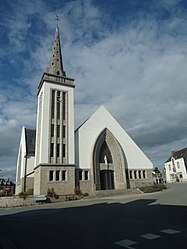
 The parish church | |
| Coordinates: 47°59′25″N 2°41′04″W / 47.9903°N 2.6844°W | |
| Country | France |
| Region | Brittany |
| Department | Morbihan |
| Arrondissement | Pontivy |
| Canton | Grand-Champ |
| Intercommunality | Pontivy Communauté |
| Government | |
| • Mayor (2020–2026) | Bernard Lecuyer[1] |
Area 1 | 38.49 km2 (14.86 sq mi) |
| Population (2022)[2] | 1,281 |
| • Density | 33/km2 (86/sq mi) |
| Time zone | UTC+01:00 (CET) |
| • Summer (DST) | UTC+02:00 (CEST) |
| INSEE/Postal code | 56160 /56120 |
| Elevation | 40–129 m (131–423 ft) |
| 1 French Land Register data, which excludes lakes, ponds, glaciers > 1 km2 (0.386 sq mi or 247 acres) and river estuaries. | |
Pleugriffet (French pronunciation: [pløɡʁifɛt]; Breton: Ploueg-Grifed) is a commune in the Morbihan department of Brittany in north-western France.[3] Inhabitants of Pleugriffet are called in French Pleugriffetois.
Population
[edit]
|
| ||||||||||||||||||||||||||||||||||||||||||||||||||||||||||||||||||||||||||||||||||||||||||||||||||||||||||||||||||
| |||||||||||||||||||||||||||||||||||||||||||||||||||||||||||||||||||||||||||||||||||||||||||||||||||||||||||||||||||
| Source: EHESS[4] and INSEE (1968-2020)[5] | |||||||||||||||||||||||||||||||||||||||||||||||||||||||||||||||||||||||||||||||||||||||||||||||||||||||||||||||||||
Geography
[edit]Pleugriffet is located 22 km (14 mi) northwest of Ploërmel, 23 km (14 mi) southeast of Pontivy and 36 km (22 mi) north of Vannes. The village belongs to upper Brittany. The commune is border by river Oust to the east. Apart from the village centre there are many hamlets in the commune.
Map
[edit]History
[edit]From 1954, the present church was rebuilt following the plans of the architect Caubert. The church was consecrated on 12 August 1956 by bishop Eugène Le Bellec. It is a Neo-Byzantine style concrete building. It was built on the site of the old Romanesque church that it replaces.


Gallery
[edit]-
The cross of Landoma, in Pleugriffet
See also
[edit]References
[edit]- ^ "Maires du Morbihan" (PDF). Préfecture du Morbihan. 7 July 2020.
- ^ "Populations de référence 2022" (in French). The National Institute of Statistics and Economic Studies. 19 December 2024.
- ^ INSEE commune file
- ^ Des villages de Cassini aux communes d'aujourd'hui: Commune data sheet Pleugriffet, EHESS (in French).
- ^ Population en historique depuis 1968, INSEE
External links
[edit]- Base Mérimée: Search for heritage in the commune, Ministère français de la Culture. (in French)
- Mayors of Morbihan Association (in French)


