Santa Maria Madalena | |
|---|---|
| Município de Santa Maria Madalena | |
 | |
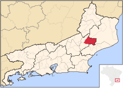
 Location of Santa Maria Madalena in the state of Rio de Janeiro | |
| Coordinates: 21°57′18″S 42°00′28″W / 21.95500°S 42.00778°W | |
| Country | |
| Region | Southeast |
| State | |
| Government | |
| • Prefeito | Carlos Botelho (DEM) |
| Area | |
• Total | 815.591 km2 (314.901 sq mi) |
| Elevation | 615 m (2,018 ft) |
| Population (2020 [1]) | |
• Total | 10,392 |
| Time zone | UTC−3 (BRT) |
| Website | [2] |
Santa Maria Madalena (Portuguese pronunciation: [ˈsɐ̃tɐ mɐˈɾi.ɐ madɐˈlẽnɐ]) is a municipality located in the Brazilian state of Rio de Janeiro. Its population was 10,392 (2020) and its area is 816 km2.[2]
The municipality contains part of the 21,444 hectares (52,990 acres) Desengano State Park, created in 1970.[3]
Climate
[edit]| Climate data for Santa Maria Madalena, Rio de Janeiro (1981–2010) | |||||||||||||
|---|---|---|---|---|---|---|---|---|---|---|---|---|---|
| Month | Jan | Feb | Mar | Apr | May | Jun | Jul | Aug | Sep | Oct | Nov | Dec | Year |
| Mean daily maximum °C (°F) | 28.4 (83.1) |
29.4 (84.9) |
28.3 (82.9) |
26.7 (80.1) |
24.5 (76.1) |
23.3 (73.9) |
23.1 (73.6) |
23.9 (75.0) |
24.2 (75.6) |
25.7 (78.3) |
26.4 (79.5) |
27.3 (81.1) |
25.9 (78.6) |
| Mean daily minimum °C (°F) | 18.8 (65.8) |
18.8 (65.8) |
18.4 (65.1) |
17.0 (62.6) |
14.9 (58.8) |
13.3 (55.9) |
13.0 (55.4) |
13.1 (55.6) |
14.5 (58.1) |
16.0 (60.8) |
17.1 (62.8) |
18.1 (64.6) |
16.1 (61.0) |
| Average precipitation mm (inches) | 245.6 (9.67) |
134.7 (5.30) |
165.9 (6.53) |
87.6 (3.45) |
60.0 (2.36) |
43.4 (1.71) |
45.9 (1.81) |
42.6 (1.68) |
93.1 (3.67) |
113.6 (4.47) |
195.0 (7.68) |
262.9 (10.35) |
1,490.3 (58.67) |
| Average precipitation days (≥ 1.0 mm) | 12 | 8 | 10 | 7 | 5 | 4 | 5 | 4 | 8 | 8 | 11 | 13 | 95 |
| Source: Instituto Nacional de Meteorologia[4] | |||||||||||||
References
[edit]- ^ IBGE 2020
- ^ IBGE - [1]
- ^ Upam Desengano flagra corte de madeira nativa em Santa Maria Madalena (in Portuguese), Inea: Instituto Estadual do Ambiente, 14 October 2015, retrieved 2017-01-12
- ^ "Normais Climatológicas Do Brasil 1981–2010" (in Portuguese). Instituto Nacional de Meteorologia. Retrieved 21 May 2024.


