| Sutherlands South Australia | |||||||||||||||
|---|---|---|---|---|---|---|---|---|---|---|---|---|---|---|---|
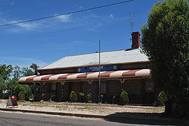
 Sutherlands Hotel | |||||||||||||||
| Coordinates | 34°09′0″S 139°13′0″E / 34.15000°S 139.21667°E | ||||||||||||||
| Population | 33 (SAL 2021)[1] | ||||||||||||||
| Postcode(s) | 5374 | ||||||||||||||
| Elevation | 234 m (768 ft) | ||||||||||||||
| Location | |||||||||||||||
| LGA(s) | Regional Council of Goyder | ||||||||||||||
| State electorate(s) | Stuart | ||||||||||||||
| Federal division(s) | Grey | ||||||||||||||
| |||||||||||||||
Sutherlands is a rural locality in the Mid North region of South Australia. It is situated 12km east of Eudunda and 125km northeast of Adelaide in the Regional Council of Goyder. As of 2021, Sutherlands has a population of 33 people.
Sutherlands was a stop on the Morgan railway line from 1878 until 1969.
As recorded in the 2021 Census, Sutherlands is a small community with a population of 33 individuals. The gender distribution is equal, with males and females each accounting for 50% of the population. The median age of the residents is 52, and there are 12 families residing in the area. The census reports a total of 26 private dwellings, with an average of 2.2 people per household. The median weekly household income is $900, and the median monthly mortgage repayments amount to $774. Renters in Sutherlands pay a median weekly rent of $150. Additionally, the town has an average of 2.5 motor vehicles per dwelling.
References
[edit]- ^ Australian Bureau of Statistics (28 June 2022). "Sutherlands (suburb and locality)". Australian Census 2021 QuickStats. Retrieved 28 June 2022.
