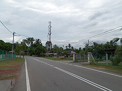
Tanjung Kling | |
|---|---|
Town | |
| Other transcription(s) | |
 Road in Tanjung Kling | |
| Coordinates: 2°14′16.3″N 102°09′16.1″E / 2.237861°N 102.154472°E | |
| State | |
| City | Malacca City |
| District | Melaka Tengah District |
| Time zone | UTC+8 (MST) |
| • Summer (DST) | Not observed |
| Postal code | 76400 |

Tanjung Kling is a coastal mukim and town in Melaka Tengah District, in the Malaysian state of Malacca.[1][2]
Infrastructures
[edit]| Image | Name | Description |
|---|---|---|
| Tanjung Bruas Port | A port constructed in late 1970s and commenced operations in early 1980s to provide port facilities and services to the local business communities and to handle the exportation of hinterland goods as well as the importation of raw materials.[3][4] | |
 |
Tanjung Kling Free Industrial Zone | Industrial Zone.[5] |
 |
Tanjung Kling Power Station |
Tourist attractions
[edit]| Image | Name | Description |
|---|---|---|
 |
Hang Tuah Mausoleum | Mausoleum of Hang Tuah.[6][7] |
 |
Puteri Beach | Formerly known as Kundor Beach, literally means Princess Beach. A beach that stretches for 2.1 km along the shore facing the Strait of Malacca on the southwestern edge of Malacca.[8][9] |
See also
[edit]References
[edit]- ^ "Tanjung Kling in Malacca". malacca.ws.
- ^ "Toponymic Guidelines for Map and Other Editors for International Use" (PDF). Malaysian National Committee on Geographical Names. 2017. p. 33. Archived from the original (PDF) on 23 May 2021. Retrieved 29 May 2021.
- ^ "Tanjung Bruas Port Website".
- ^ "Tanjung Bruas Port Sdn Bhd". MMC Group. Retrieved 24 April 2022.
- ^ "The historic state and city : Melaka today". melaka.net.
- ^ "Hang Tuah's Mausoleum - GOGO Melaka - Malacca Tourist Guide". gogomelaka.com.
- ^ "Jelajah ibu negeri - Pelancongan - Utusan Online". www.utusan.com.my. Archived from the original on 27 March 2015.
- ^ Hamid, Rizanizam Abdul (14 September 2020). "Pantai Puteri boleh 'lenyap' dari peta Malaysia" [Puteri Beach May 'Disappear' from Malaysian Map] (in Malay). Retrieved 5 July 2021.
- ^ Chung, Nicholas (4 May 2021). "Malaccans push for federal action to stop major reclamation job". FMT. Retrieved 25 May 2021.
