| Var | |
|---|---|
 Rooftops of Entrevaux and the gorge of the Var | |
 | |
| Location | |
| Country | France |
| Physical characteristics | |
| Source | |
| • location | Maritime Alps |
| • elevation | 1,800 m (5,900 ft) |
| Mouth | |
• location | Mediterranean Sea |
• coordinates | 43°39′13″N 7°11′59″E / 43.65361°N 7.19972°E |
| Length | 114 km (71 mi) |
| Basin size | 2,812 km2 (1,086 sq mi) |
| Discharge | |
| • average | 50 to 100 m3/s (1,800 to 3,500 cu ft/s) |
 | |
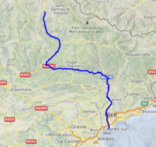
The Var (French: [vaʁ] ⓘ, Occitan: [ˈbaɾ]; Italian: Varo; Latin: Varus) is a river located in the southeast of France. It is 114 km (71 mi) long.[1] Its drainage basin is 2,812 km2 (1,086 sq mi).[2]
The Var flows through the Alpes-Maritimes département for most of its length, with a short (~15 km or ~9 mi) stretch in the Alpes-de-Haute-Provence département. It is a unique case in France of a river not flowing in the département named after it (see Var).
Until the beginning of the 19th century, the river had no bridges; it was the border between France and the County of Nice, then part of Kingdom of Piedmont-Sardinia.
Name
[edit]The river name is attested in Latin as Vārus and in Ancient Greek as Ouãros (Οὐᾶρος). It stems from the Indo-European root *uōr- (earlier *uer-), meaning 'water, river' (cf. Sanskrit vār, Old Norse vari).[3]
Hydrography
[edit]The Var rises near the Col de la Cayolle (2,326 m/7,631 ft) in the Maritime Alps and flows generally southeast to its outflow into the Mediterranean Sea between Nice and Saint-Laurent-du-Var. Its main tributaries are the Cians, the Tinée, the Vésubie, the Coulomp, the Estéron, the Tuébi, the Chalvagne, the Barlatte, the Bourdous and the Roudoule.[1]
The Var flows through the following départements and towns:
- Alpes-Maritimes: Guillaumes
- Alpes-de-Haute-Provence: Entrevaux
- Alpes-Maritimes: Puget-Théniers, Carros, Saint-Laurent-du-Var
References
[edit]- ^ a b Sandre. "Fiche cours d'eau - Le Var (Y6--0200)".
- ^ Bassin versant : Var (Le), Observatoire Régional Eau et Milieux Aquatiques en PACA
- ^ Delamarre 2003, p. 301.
Bibliography
- Delamarre, Xavier (2003). Dictionnaire de la langue gauloise: Une approche linguistique du vieux-celtique continental. Errance. ISBN 9782877723695.