
The United States Census Bureau separates places by incorporation for statistical purposes during its decennial census. To incorporate, communities may need to meet statutory requirements made by their respective state, such as thresholds in population or specificities relative to location.[a] Federally, the Census Bureau defines incorporated places as areas, whose boundaries do not cross state lines, that "provide governmental functions for a concentration of people", as opposed to "minor civil [divisions], which generally ... provide services or administer an area without regard, necessarily, to population".[5] Unincorporated communities, classified as census-designated places (CDPs), lack elected municipal officers and boundaries with legal status.[5] The Bureau identified 169 CDPs in the state of West Virginia at the 2010 census.
The Municipal Code of West Virginia, which governs incorporation, requires applicant municipal corporations (places for incorporation) that cover an area more than 1 square mile (2.6 km2) to have a minimum of 500 inhabitants or freeholders per square mile, and those under 1 square mile to have at least 100 inhabitants or freeholders. Applicant areas must not reside within a municipality "urban in character", nor claim an area "disproportionate to its number of inhabitants".[6] Upon approval, the state classifies municipal corporations as a Class I city, with a population of more than fifty thousand, a Class II city, with a population between ten thousand and fifty thousand, a Class III city, with a population between two thousand and ten thousand, or a Class IV town or village, with a population of less than two thousand.[7] All municipalities can "use a common seal", defend, maintain, or institute a proceeding in court, and hold, take, purchase, or lease, as lessee, property for municipal purposes.[8]
Of the fifty-five counties in West Virginia, Logan is home to the most CDPs, with twenty-two, followed by Fayette, with eighteen, and Raleigh, with fifteen. The largest CDP by population is Teays Valley, with 13,175 residents, while Bowden, with 9 residents over 0.12 square miles (0.31 km2), represents the state's smallest CDP by both population and area.[9]
Census-designated places
[edit]-

-
 The houses of Boomer, as seen from across the Kanawha River in May 1975
 -
 A child returning to school with an ice cream cone in Chattaroy. Photographed as a part of the DOCUMERICA series, which aimed to "photographically document subjects of environmental concern", the image's title states that Chattaroy "[had] no industry" and that "most of the people [survived] on welfare, pensions, Social Security, and black lung benefits" in April 1974.[13][14]
 -

-
-
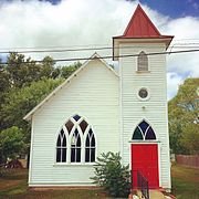 Otterbein United Methodist Church in Green Spring
 -
 The Daniel Fry House in Middleway
 -

-
 The Red Jacket Consolidated Coal and Coke Company constructed Red Jacket (pictured) in 1905.[18]
 -
 A post office in Shenandoah Junction
 -
 The Peerless Coal Company Store in Vivian was listed on the National Register of Historic Places in 1992.[19]


See also
[edit]Explanatory notes
[edit]- ^ Mississippi, for instance, only requires potential incorporated areas to have a population of 300, whereas Florida requires potential incorporated areas to have a population of at least 1,500 if the county in which the area resides has a population of 75,000 or less, or of at least 7,500 if the county in which the area resides has a population of more than 75,000.[3][4]
- ^ If the CDP covers more than one county, the county that contains a majority of the CDP's population is listed first.
- ^ During the 2000 United States Census, the Census Bureau counted the communities of Amherstdale and Robinette together as Amherstdale-Robinette; in 2010, the Bureau made a distinction between the two. A part of Accoville was also formed from the disbanded CDP. The population total, total area, and coordinates of Amherstdale-Robinette reflect the 2000 census.[9][10][11]
References
[edit]- ^ Chambers, S. Allen (2004). Buildings of West Virginia. Oxford University Press. p. 199. ISBN 978-0-19-516548-7.
- ^ "National Register of Historic Places Registration Form, Itmann Company Store and Office". National Register of Historic Places. National Park Service. July 9, 1990. pp. 1, 5, 7. Archived from the original (DjVu) on June 17, 2015.
- ^ Mississippi Code Annotated §21-1-1 Archived 2015-04-07 at the Wayback Machine. 2010.
- ^ Florida Statutes §165.061 Archived 2015-05-29 at the Wayback Machine. 2014.
- ^ a b "Geographic Terms and Concepts– Place". United States Census Bureau. United States Department of Commerce. Archived from the original on February 19, 2014. Retrieved February 24, 2014.
- ^ West Virginia Code §8-2-1 Archived 2015-05-29 at the Wayback Machine. Updated through the 2014 1st Special Session.
- ^ West Virginia Code §8-1-3 Archived 2011-05-27 at the Wayback Machine. Updated through the 2014 1st Special Session.
- ^ West Virginia Code §8-12-1 Archived 2015-05-29 at the Wayback Machine. Updated through the 2014 1st Special Session.
- ^ a b c "American Factfinder". United States Census Bureau. United States Department of Commerce. Archived from the original on February 14, 2020. Retrieved August 18, 2014.
- ^ "West Virginia: 2010" (PDF). United States Census Bureau. United States Department of Commerce. September 2012. pp. 19–22. Archived (PDF) from the original on February 13, 2017.
- ^ "Places2k". United States Census Bureau. United States Department of Commerce. Archived from the original (Zip) on October 11, 2013. Retrieved August 19, 2014.
- ^ Gannett, Henry (1904). A Gazetteer of Virginia and West Virginia. Genealogical Publishing Company. p. 23. ISBN 9780806306575. Archived from the original on January 7, 2018.
- ^ DOCUMERICA: The Environmental Protection Agency's Program to Photographically Document Subjects of Environmental Concern, 1972–1977. Record Group 412: Records of the Environmental Protection Agency, 1944 - 2006. National Archives and Records Administration. Archived from the original on August 2, 2014. Retrieved August 20, 2014.
{{cite book}}:|work=ignored (help) - ^ Corn, Jack (April 1974). Youngster Returning to School after Going Home During Recess to Get an Ice Cream Cone... Series: DOCUMERICA: The Environmental Protection Agency's Program to Photographically Document Subjects of Environmental Concern, 1944 - 2006. National Archives and Records Administration. Archived from the original on October 4, 2020. Retrieved September 3, 2017.
{{cite book}}:|work=ignored (help) - ^ Corn, Jack (June 1974). Coal City Club in Coal City, West Virginia, a Part of Beckley... Series: DOCUMERICA: The Environmental Protection Agency's Program to Photographically Document Subjects of Environmental Concern, 1944 - 2006. National Archives and Records Administration. Archived from the original on October 4, 2020. Retrieved September 3, 2017.
{{cite book}}:|work=ignored (help) - ^ "National Register of Historic Places– Inventory Nomination Form, Bank of Glen Jean" (PDF). National Register of Historic Places. National Park Service. December 21, 1982. p. 2.
- ^ Schaefer, Harry (June 1973). Rand, West Virginia, with much of its population living in poverty... Series: DOCUMERICA: The Environmental Protection Agency's Program to Photographically Document Subjects of Environmental Concern, 1944 - 2006. National Archives and Records Administration. Archived from the original on October 4, 2020. Retrieved September 3, 2017.
{{cite book}}:|work=ignored (help) - ^ Torok, George D (2004). A Guide to Historic Coal Towns of the Big Sandy River Valley. University of Tennessee Press. p. 124. ISBN 978-1-57233-282-9. Archived from the original on January 7, 2018.
- ^ "National Register of Historic Places Registration Form, Peerless Coal Company Store" (PDF). National Register of Historic Places. National Park Service. April 17, 1992. p. 2.