Monchy-le-Preux | |
|---|---|
 The townhall | |
 Coat of arms | |
Location of Monchy-le-Preux  | |
 Monchy-le-Preux  Monchy-le-Preux | |
| Coordinates: 50°16′14″N 2°53′39″E / 50.2706°N 2.8942°E | |
| Country | France |
| Region | Hauts-de-France |
| Department | Pas-de-Calais |
| Arrondissement | Arras |
| Canton | Arras-2 |
| Intercommunality | CU d'Arras |
| Government | |
| • Mayor (2020–2026) | Olivier Degauquier[1] |
Area 1 | 9.26 km2 (3.58 sq mi) |
| Population (2022)[2] | 656 |
| • Density | 71/km2 (180/sq mi) |
| Time zone | UTC+01:00 (CET) |
| • Summer (DST) | UTC+02:00 (CEST) |
| INSEE/Postal code | 62582 /62118 |
| Elevation | 52–113 m (171–371 ft) (avg. 107 m or 351 ft) |
| 1 French Land Register data, which excludes lakes, ponds, glaciers > 1 km2 (0.386 sq mi or 247 acres) and river estuaries. | |
Monchy-le-Preux (French pronunciation: [mɔ̃ʃi lə pʁø]) is a commune in the Pas-de-Calais department in the Hauts-de-France region of France[3] 6 miles (10 km) southeast of Arras.
History
[edit]During World War I ten Commonwealth soldiers fought off a German counterattack in April 1917 and kept the village from German occupation.[4]
Population
[edit]| Year | Pop. | ±% p.a. |
|---|---|---|
| 1968 | 465 | — |
| 1975 | 423 | −1.34% |
| 1982 | 455 | +1.05% |
| 1990 | 487 | +0.85% |
| 1999 | 521 | +0.75% |
| 2007 | 571 | +1.15% |
| 2012 | 676 | +3.43% |
| 2017 | 651 | −0.75% |
| Source: INSEE[5] | ||
Places of interest
[edit]- Monchy-le-Preux (Newfoundland) Memorial commemorating soldiers of the Newfoundland Regiment in World War I.
- Windmill British Cemetery
-
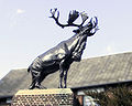 The caribou monument to the Newfoundland Regiment
 -
 The commemorative plaque


See also
[edit]References
[edit]- ^ "Répertoire national des élus: les maires". data.gouv.fr, Plateforme ouverte des données publiques françaises (in French). 9 August 2021.
- ^ "Populations de référence 2022" (in French). The National Institute of Statistics and Economic Studies. 19 December 2024.
- ^ INSEE commune file
- ^ Roberts, Terry (23 May 2024). "Return to Monchy, a moment with a casket, stirs emotions as anticipation builds over return of N.L. soldier". CBC News. Retrieved 24 May 2024.
- ^ Population en historique depuis 1968, INSEE
External links
[edit]Wikimedia Commons has media related to Monchy-le-Preux.
| International | |
|---|---|
| National | |
| Other | |
This Arras arrondissement, Pas-de-Calais geographical article is a stub. You can help Wikipedia by expanding it. |